Geolocate

Lowell topographic map

Click on the map to display elevation.

About this map

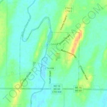
Name: Lowell topographic map, elevation, terrain.

Location: Lowell, Dodge County, Wisconsin, 53557, United States (43.32891 -88.82873 43.34678 -88.80804)

Average elevation: 823 ft

Minimum elevation: 787 ft

Maximum elevation: 896 ft

Dodge County trails, hiking, mountain biking, running and outdoor activities

Other topographic maps

Click on a map to view its topography, its elevation and its terrain.

Lebanon

United States > Wisconsin > Dodge County

Average elevation: 912 ft

Ashippun

United States > Wisconsin > Dodge County

Average elevation: 892 ft

Burnett

United States > Wisconsin > Dodge County

Average elevation: 892 ft

Rubicon

United States > Wisconsin > Dodge County

Average elevation: 1,040 ft

Gear up for your next adventure:

👟Men's Trail Runners - Lightweight footwear for fast-paced exploration and light hiking
GPS Sports Watch - GPS watch for running, hiking and training
🔦Powerful Headlamps - Ultra-bright hands-free lighting for night navigation
🪶Wildlife Field Guides - Learn animal tracking and species ID
🎒Hydration Pack - Hands‑free water reservoir for long hikes

As an Amazon Associate, this site earns from qualifying purchases at no extra cost to you.