
Make a donation
Gear up for your next adventure:
As an Amazon Associate, this site earns from qualifying purchases at no extra cost to you.
Boxberg topographic map
Click on the map to display elevation.
Make a donation
Gear up for your next adventure:
As an Amazon Associate, this site earns from qualifying purchases at no extra cost to you.
About this map
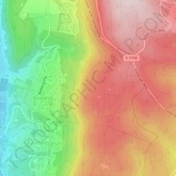
Name: Boxberg topographic map, elevation, terrain.
Location: Boxberg, Heidelberg, Baden-Württemberg, Deutschland (49.36690 8.70015 49.38382 8.73040)
Average elevation: 1,115 ft
Minimum elevation: 400 ft
Maximum elevation: 1,713 ft
Make a donation
Gear up for your next adventure:
As an Amazon Associate, this site earns from qualifying purchases at no extra cost to you.
Other topographic maps
Click on a map to view its topography, its elevation and its terrain.
Königstuhl
Deutschland > Baden-Württemberg > Heidelberg
Im südlich des Neckars liegenden Königstuhlmassiv stehen mächtige Schichten aus Buntsandstein an. Felsen aus diesem Gesteins rutschten in Auftauphasen zum Ende des Eiszeitalters auf Permafrostböden abwärts und bildeten an den Massivnordhängen im Übergangsbereich zum Auerhahnenkopf (486,9 m) oberhalb von…
Average elevation: 1,263 ft
Make a donation
Gear up for your next adventure:
As an Amazon Associate, this site earns from qualifying purchases at no extra cost to you.
Kohlhof
Deutschland > Baden-Württemberg > Heidelberg
Der Kohlhof liegt in 430–480 m ü. NHN am linken Hang und auf dem Talgrund der flachen, ostwärts verlaufenden Mulde des zum oberen Hilsbach auslaufenden Michelsbrunnengrabens gut anderthalb Kilometer südlich des Königstuhl-Gipfels. Das Wetter weicht häufig von dem des tiefer gelegenen Stadtgebiets ab,…
Average elevation: 1,463 ft