
Make a donation
Gear up for your next adventure:
As an Amazon Associate, this site earns from qualifying purchases at no extra cost to you.
Haarlass topographic map
Click on the map to display elevation.
Make a donation
Gear up for your next adventure:
As an Amazon Associate, this site earns from qualifying purchases at no extra cost to you.
About this map
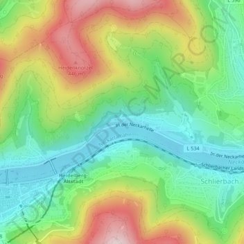
Name: Haarlass topographic map, elevation, terrain.
Average elevation: 820 ft
Minimum elevation: 338 ft
Maximum elevation: 1,585 ft
Make a donation
Gear up for your next adventure:
As an Amazon Associate, this site earns from qualifying purchases at no extra cost to you.
Other topographic maps
Click on a map to view its topography, its elevation and its terrain.
Make a donation
Gear up for your next adventure:
As an Amazon Associate, this site earns from qualifying purchases at no extra cost to you.
Kohlhof
Deutschland > Baden-Württemberg > Heidelberg
Der Kohlhof liegt in 430–480 m ü. NHN am linken Hang und auf dem Talgrund der flachen, ostwärts verlaufenden Mulde des zum oberen Hilsbach auslaufenden Michelsbrunnengrabens gut anderthalb Kilometer südlich des Königstuhl-Gipfels. Das Wetter weicht häufig von dem des tiefer gelegenen Stadtgebiets ab,…
Average elevation: 1,463 ft