
Make a donation
Gear up for your next adventure:
As an Amazon Associate, this site earns from qualifying purchases at no extra cost to you.
Paddockwood No. 520 topographic map
Click on the map to display elevation.
Make a donation
Gear up for your next adventure:
As an Amazon Associate, this site earns from qualifying purchases at no extra cost to you.
About this map
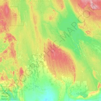
Name: Paddockwood No. 520 topographic map, elevation, terrain.
Location: Paddockwood No. 520, Division No. 15, Saskatchewan, Canada (53.45233 -106.00457 53.97630 -105.10108)
Average elevation: 1,713 ft
Minimum elevation: 1,558 ft
Maximum elevation: 2,008 ft
Make a donation
Gear up for your next adventure:
As an Amazon Associate, this site earns from qualifying purchases at no extra cost to you.
Other topographic maps
Click on a map to view its topography, its elevation and its terrain.
Jumping Lake
Canada > Saskatchewan > Division No. 15 > Invergordon No. 430 > Waitville
Average elevation: 1,640 ft
Make a donation
Gear up for your next adventure:
As an Amazon Associate, this site earns from qualifying purchases at no extra cost to you.