
Fairchild topographic map
Click on the map to display elevation.
About this map
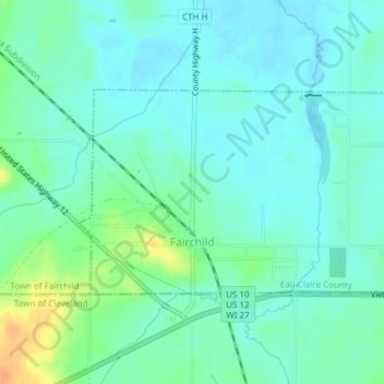
Name: Fairchild topographic map, elevation, terrain.
Location: Fairchild, Eau Claire County, Wisconsin, United States (44.59653 -90.97422 44.61094 -90.94237)
Average elevation: 1,053 ft
Minimum elevation: 1,020 ft
Maximum elevation: 1,148 ft
Eau Claire County trails, hiking, mountain biking, running and outdoor activities
Other topographic maps
Click on a map to view its topography, its elevation and its terrain.
Cleghorn
United States > Wisconsin > Eau Claire County > Town of Pleasant Valley
Average elevation: 1,007 ft
Pinehurst Park
United States > Wisconsin > Eau Claire County > Eau Claire > Pinehurst
Average elevation: 948 ft