Geolocate

Rodell topographic map

Click on the map to display elevation.

About this map

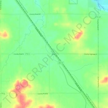
Name: Rodell topographic map, elevation, terrain.

Location: Rodell, Town of Lincoln, Eau Claire County, Wisconsin, United States (44.69996 -91.20821 44.73996 -91.16821)

Average elevation: 965 ft

Minimum elevation: 866 ft

Maximum elevation: 1,112 ft

Eau Claire County trails, hiking, mountain biking, running and outdoor activities

Other topographic maps

Click on a map to view its topography, its elevation and its terrain.

Augusta

United States > Wisconsin > Eau Claire County

Average elevation: 991 ft

Seymour

United States > Wisconsin > Eau Claire County

Average elevation: 902 ft

Fairchild

United States > Wisconsin > Eau Claire County

Average elevation: 1,053 ft

Gear up for your next adventure:

🔥Plasma Lighters - Windproof lighters that work in any weather condition
🗺️NatGeo Topo Maps - High-quality waterproof printed topographic maps of US Parks
🏥Hiking First Aid Kits - Comprehensive medical kits for remote trail injuries
🪶LED Camping Lantern - Bright lantern for camp lighting
🗺️Topographic Maps - Detailed topo maps for hiking, exploring and outdoor navigation

As an Amazon Associate, this site earns from qualifying purchases at no extra cost to you.