
Make a donation
Gear up for your next adventure:
As an Amazon Associate, this site earns from qualifying purchases at no extra cost to you.
Murehwa topographic map
Click on the map to display elevation.
Make a donation
Gear up for your next adventure:
As an Amazon Associate, this site earns from qualifying purchases at no extra cost to you.
About this map
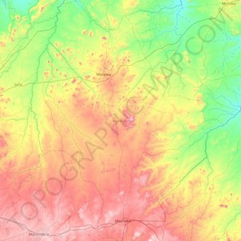
Name: Murehwa topographic map, elevation, terrain.
Location: Murehwa, Mashonaland East Province, Zimbabwe (-18.21387 31.51577 -17.39377 32.20787)
Average elevation: 4,265 ft
Minimum elevation: 3,245 ft
Maximum elevation: 5,791 ft
Make a donation
Gear up for your next adventure:
As an Amazon Associate, this site earns from qualifying purchases at no extra cost to you.
Other topographic maps
Click on a map to view its topography, its elevation and its terrain.
Make a donation
Gear up for your next adventure:
As an Amazon Associate, this site earns from qualifying purchases at no extra cost to you.
Marondera
Zimbabwe > Mashonaland East Province > Marondera
Marondera is situated on the highveld plateau, and has a subtropical highland climate (Köppen Cwb). The city enjoys a sunny climate, with the summer months (October to April) characterised by warm to hot days followed by afternoon thundershowers and cool evenings, and the winter months (May to September) by…
Average elevation: 5,371 ft