
Old Fort topographic map
Click on the map to display elevation.
About this map
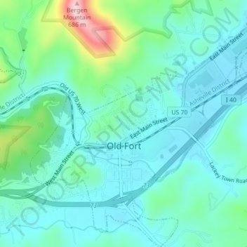
Name: Old Fort topographic map, elevation, terrain.
Location: Old Fort, McDowell County, North Carolina, United States (35.61726 -82.19397 35.64572 -82.15928)
Average elevation: 1,555 ft
Minimum elevation: 1,385 ft
Maximum elevation: 2,205 ft
McDowell County trails, hiking, mountain biking, running and outdoor activities
Other topographic maps
Click on a map to view its topography, its elevation and its terrain.
Little Switzerland
United States > North Carolina > McDowell County
Little Switzerland is an unincorporated community in McDowell and Mitchell counties of North Carolina, United States. It is located along North Carolina Highway 226A (NC 226A) off the Blue Ridge Parkway, directly north of Marion and south of Spruce Pine. The elevation is 3,468 feet (1,057 m) above sea level.
Average elevation: 3,068 ft
Structure Number Six B Dam
United States > North Carolina > McDowell County
Average elevation: 1,545 ft
Structure Number Six B Dam
United States > North Carolina > McDowell County
Average elevation: 1,545 ft
Little Switzerland
United States > North Carolina > McDowell County
Little Switzerland is an unincorporated community in McDowell and Mitchell counties of North Carolina, United States. It is located along North Carolina Highway 226A (NC 226A) off the Blue Ridge Parkway, directly north of Marion and south of Spruce Pine. The elevation is 3,468 feet (1,057 m) above sea level.
Average elevation: 3,068 ft