

Little Switzerland topographic map
Click on the map to display elevation.
Little Switzerland
Little Switzerland is an unincorporated community in McDowell and Mitchell counties of North Carolina, United States. It is located along North Carolina Highway 226A (NC 226A) off the Blue Ridge Parkway, directly north of Marion and south of Spruce Pine. The elevation is 3,468 feet (1,057 m) above sea level.
About this map
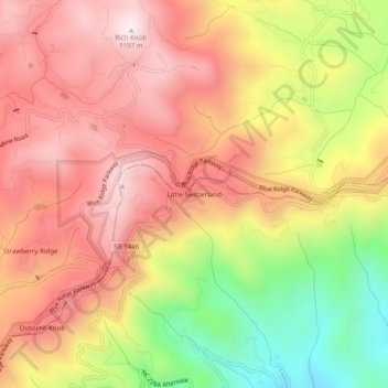
Name: Little Switzerland topographic map, elevation, terrain.
Average elevation: 3,068 ft
Minimum elevation: 1,818 ft
Maximum elevation: 3,924 ft
McDowell County trails, hiking, mountain biking, running and outdoor activities
Other topographic maps
Click on a map to view its topography, its elevation and its terrain.
Marion
United States > North Carolina > McDowell County
With an elevation of 1,400 feet, Marion's climate is fairly warm during summer (which are typically longer than lower elevation areas in the United States that get the same average high and low temperatures in the summer), when temperatures tend to be in the 80s and 90s, and moderately cold during the winter,…
Average elevation: 1,427 ft
Bobs Creek State Natural Area
United States > North Carolina > McDowell County
Average elevation: 1,542 ft

Marion
United States > North Carolina > McDowell County
With an elevation of 1,400 feet, Marion's climate is fairly warm during summer (which are typically longer than lower elevation areas in the United States that get the same average high and low temperatures in the summer), when temperatures tend to be in the 80s and 90s, and moderately cold during the winter,…
Average elevation: 1,427 ft
Marion
United States > North Carolina > McDowell County
With an elevation of 1,400 feet (430 m), Marion's climate is fairly warm during summer (which are typically longer than lower elevation areas in the United States that get the same average high and low temperatures in the summer), when temperatures tend to be in the 80s °F (high 20s °C) and 90s °F (30s…
Average elevation: 1,427 ft