Geolocate

Pine Center topographic map

Click on the map to display elevation.

About this map

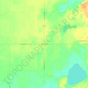
Name: Pine Center topographic map, elevation, terrain.

Location: Pine Center, Crow Wing County, Minnesota, United States (46.19441 -93.93443 46.23441 -93.89443)

Average elevation: 1,302 ft

Minimum elevation: 1,243 ft

Maximum elevation: 1,355 ft

Crow Wing County trails, hiking, mountain biking, running and outdoor activities

Other topographic maps

Click on a map to view its topography, its elevation and its terrain.

Jenkins

United States > Minnesota > Crow Wing County

Average elevation: 1,266 ft

Emily Lake

United States > Minnesota > Crow Wing County > Emily

Average elevation: 1,266 ft

Nokay Lake

United States > Minnesota > Crow Wing County

Average elevation: 1,247 ft

Bird Island

United States > Minnesota > Crow Wing County

Average elevation: 1,266 ft

Platte Lake

United States > Minnesota > Crow Wing County

Average elevation: 1,260 ft

Boom Lake

United States > Minnesota > Crow Wing County > Brainerd

Average elevation: 1,204 ft

Gear up for your next adventure:

🧥Men's Rain Shells - Premium waterproof and breathable jackets for mountain weather
🧯Emergency Survival Kit - All‑in‑one survival essentials for the backcountry
🧦Hiking Socks - Comfortable socks to prevent blisters on long hikes
🔌Solar Panel Charger - Charge gear sustainably outdoors
🏔️Mountain Trail Maps - High‑detail maps for popular peaks

As an Amazon Associate, this site earns from qualifying purchases at no extra cost to you.