
Make a donation
Gear up for your next adventure:
As an Amazon Associate, this site earns from qualifying purchases at no extra cost to you.
Nokay Lake topographic map
Click on the map to display elevation.
Make a donation
Gear up for your next adventure:
As an Amazon Associate, this site earns from qualifying purchases at no extra cost to you.
About this map
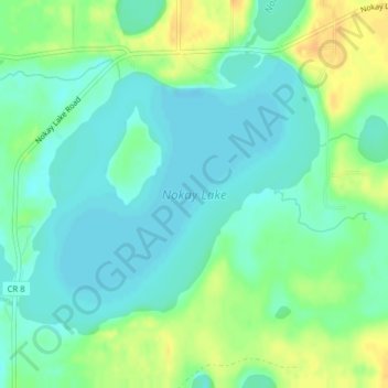
Name: Nokay Lake topographic map, elevation, terrain.
Location: Nokay Lake, Crow Wing County, Minnesota, United States (46.36855 -93.97851 46.38816 -93.94805)
Average elevation: 1,247 ft
Minimum elevation: 1,211 ft
Maximum elevation: 1,306 ft
Crow Wing County trails, hiking, mountain biking, running and outdoor activities
Make a donation
Gear up for your next adventure:
As an Amazon Associate, this site earns from qualifying purchases at no extra cost to you.
Other topographic maps
Click on a map to view its topography, its elevation and its terrain.
Make a donation
Gear up for your next adventure:
As an Amazon Associate, this site earns from qualifying purchases at no extra cost to you.
Brainerd
United States > Minnesota > Crow Wing County > Brainerd > Brainerd
Average elevation: 1,211 ft