
Make a donation
Gear up for your next adventure:
As an Amazon Associate, this site earns from qualifying purchases at no extra cost to you.
Central Park topographic map
Click on the map to display elevation.
Make a donation
Gear up for your next adventure:
As an Amazon Associate, this site earns from qualifying purchases at no extra cost to you.
About this map
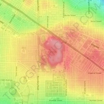
Name: Central Park topographic map, elevation, terrain.
Average elevation: 371 ft
Minimum elevation: 131 ft
Maximum elevation: 512 ft
Make a donation
Gear up for your next adventure:
As an Amazon Associate, this site earns from qualifying purchases at no extra cost to you.
Other topographic maps
Click on a map to view its topography, its elevation and its terrain.
Burnaby
Canada > British Columbia > Metro Vancouver Regional District > Burnaby
Burnaby occupies 98.60 square kilometres (38.07 sq mi) and is located at the geographic centre of the Metro Vancouver area and home to the Metro Vancouver regional government in Metrotown. Situated between the city of Vancouver on the west and Port Moody, Coquitlam, and New Westminster on the east, Burnaby is…
Average elevation: 472 ft
Deer Lake
Canada > British Columbia > Metro Vancouver Regional District > Burnaby
Average elevation: 197 ft
Burnaby Mountain
Canada > British Columbia > Metro Vancouver Regional District > Burnaby
Due to its relatively high elevation, snow will often fall on the higher levels of Burnaby Mountain while rain falls in the surrounding cities. Tobogganing is a popular pastime at Centennial Park on winter days with snow.
Average elevation: 548 ft
Deer Lake Park
Canada > British Columbia > Metro Vancouver Regional District > Burnaby
Average elevation: 210 ft
Make a donation
Gear up for your next adventure:
As an Amazon Associate, this site earns from qualifying purchases at no extra cost to you.
Burnaby Lake
Canada > British Columbia > Metro Vancouver Regional District > Burnaby
Average elevation: 105 ft
Brentwood
Canada > British Columbia > Metro Vancouver Regional District > Burnaby
Average elevation: 226 ft
Stride Hill
Canada > British Columbia > Metro Vancouver Regional District > Burnaby
Average elevation: 223 ft
Maywood
Canada > British Columbia > Metro Vancouver Regional District > Burnaby
Average elevation: 371 ft
Make a donation
Gear up for your next adventure:
As an Amazon Associate, this site earns from qualifying purchases at no extra cost to you.
Government Road
Canada > British Columbia > Metro Vancouver Regional District > Burnaby
Average elevation: 148 ft
Burnaby Mountain
Canada > British Columbia > Metro Vancouver Regional District > Burnaby
Due to its relatively high elevation, snow will often fall on the higher levels of Burnaby Mountain while rain falls in the surrounding cities. Tobogganing is a popular pastime at Centennial Park on winter days with snow.
Average elevation: 548 ft