
Make a donation
Gear up for your next adventure:
As an Amazon Associate, this site earns from qualifying purchases at no extra cost to you.
Greenville topographic map
Click on the map to display elevation.
Make a donation
Gear up for your next adventure:
As an Amazon Associate, this site earns from qualifying purchases at no extra cost to you.
Greenville
Greenville's highest point is Barrett Hill, near the western border of the town, with an elevation of 1,270 feet (390 m) above sea level. The northern half of the town is drained by the Souhegan River, while the southern half is drained by tributaries of Walker Brook and Mason Brook, which flow south to the Squannacook River, a tributary of the Nashua River in Massachusetts. The entire town is within the Merrimack River watershed.
Make a donation
Gear up for your next adventure:
As an Amazon Associate, this site earns from qualifying purchases at no extra cost to you.
About this map
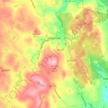
Name: Greenville topographic map, elevation, terrain.
Average elevation: 945 ft
Minimum elevation: 545 ft
Maximum elevation: 1,263 ft
Hillsborough County trails, hiking, mountain biking, running and outdoor activities
Make a donation
Gear up for your next adventure:
As an Amazon Associate, this site earns from qualifying purchases at no extra cost to you.
Other topographic maps
Click on a map to view its topography, its elevation and its terrain.
North Brookline
United States > New Hampshire > Hillsborough County > Brookline
Average elevation: 407 ft
Crotched Mountain
United States > New Hampshire > Hillsborough County > Francestown
Average elevation: 1,375 ft
Make a donation
Gear up for your next adventure:
As an Amazon Associate, this site earns from qualifying purchases at no extra cost to you.
West Peterborough
United States > New Hampshire > Hillsborough County > Peterborough
Average elevation: 981 ft
Make a donation
Gear up for your next adventure:
As an Amazon Associate, this site earns from qualifying purchases at no extra cost to you.
East Merrimack
United States > New Hampshire > Hillsborough County > Merrimack
Average elevation: 180 ft
Perham Corner
United States > New Hampshire > Hillsborough County > Lyndeborough
Average elevation: 551 ft
Gibson Four Corners
United States > New Hampshire > Hillsborough County > New Ipswich
Average elevation: 1,076 ft
Make a donation
Gear up for your next adventure:
As an Amazon Associate, this site earns from qualifying purchases at no extra cost to you.
Manchester
United States > New Hampshire > Hillsborough County > Manchester
According to the United States Census Bureau, the city has a total area of 35.0 square miles (90.6 km2), of which 33.1 square miles (85.7 km2) are land and 1.9 square miles (4.8 km2) are water, comprising 5.33% of the city. Manchester is drained by the Merrimack River and its tributaries the Piscataquog River…
Average elevation: 413 ft
Cricket Corner
United States > New Hampshire > Hillsborough County > Amherst
Average elevation: 256 ft
Make a donation
Gear up for your next adventure:
As an Amazon Associate, this site earns from qualifying purchases at no extra cost to you.
Mountain Base
United States > New Hampshire > Hillsborough County > Goffstown
Average elevation: 679 ft