
Make a donation
Gear up for your next adventure:
As an Amazon Associate, this site earns from qualifying purchases at no extra cost to you.
Hillsborough topographic map
Click on the map to display elevation.
Make a donation
Gear up for your next adventure:
As an Amazon Associate, this site earns from qualifying purchases at no extra cost to you.
About this map
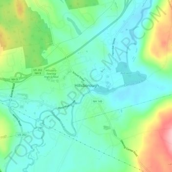
Name: Hillsborough topographic map, elevation, terrain.
Average elevation: 830 ft
Minimum elevation: 476 ft
Maximum elevation: 1,490 ft
Hillsborough County trails, hiking, mountain biking, running and outdoor activities
Make a donation
Gear up for your next adventure:
As an Amazon Associate, this site earns from qualifying purchases at no extra cost to you.
Other topographic maps
Click on a map to view its topography, its elevation and its terrain.
Merrimack River
United States > New Hampshire > Hillsborough County > Nashua
Average elevation: 253 ft
Make a donation
Gear up for your next adventure:
As an Amazon Associate, this site earns from qualifying purchases at no extra cost to you.
Massabesic Lake
United States > New Hampshire > Hillsborough County > Manchester
Average elevation: 295 ft
Greenville
United States > New Hampshire > Hillsborough County
Greenville's highest point is Barrett Hill, near the western border of the town, with an elevation of 1,270 feet (390 m) above sea level. The northern half of the town is drained by the Souhegan River, while the southern half is drained by tributaries of Walker Brook and Mason Brook, which flow south to the…
Average elevation: 945 ft