
Make a donation
Gear up for your next adventure:
As an Amazon Associate, this site earns from qualifying purchases at no extra cost to you.
Aschenberg topographic map
Click on the map to display elevation.
Make a donation
Gear up for your next adventure:
As an Amazon Associate, this site earns from qualifying purchases at no extra cost to you.
About this map
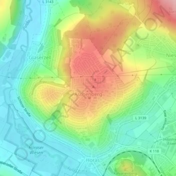
Name: Aschenberg topographic map, elevation, terrain.
Location: Aschenberg, Fulda, Landkreis Fulda, Hessen, Deutschland (50.56506 9.64181 50.58661 9.67190)
Average elevation: 974 ft
Minimum elevation: 778 ft
Maximum elevation: 1,299 ft
Make a donation
Gear up for your next adventure:
As an Amazon Associate, this site earns from qualifying purchases at no extra cost to you.
Other topographic maps
Click on a map to view its topography, its elevation and its terrain.
Fulda
Deutschland > Hessen > Landkreis Fulda > Fulda
Die Stadt Fulda liegt nahe der Mitte Deutschlands in Hessen; die Landesgrenzen zu Bayern und Thüringen liegen 15 km südsüdöstlich und 25 km östlich. Am Oberlauf des Flusses Fulda ist sie eingebettet in die Fuldaer Senke zwischen dem Fulda-Haune-Tafelland im Norden sowie den Mittelgebirgen Rhön im Osten…
Average elevation: 1,004 ft