
Make a donation
Gear up for your next adventure:
As an Amazon Associate, this site earns from qualifying purchases at no extra cost to you.
Fulda topographic map
Click on the map to display elevation.
Make a donation
Gear up for your next adventure:
As an Amazon Associate, this site earns from qualifying purchases at no extra cost to you.
Fulda
Die Stadt Fulda liegt nahe der Mitte Deutschlands in Hessen; die Landesgrenzen zu Bayern und Thüringen liegen 15 km südsüdöstlich und 25 km östlich. Am Oberlauf des Flusses Fulda ist sie eingebettet in die Fuldaer Senke zwischen dem Fulda-Haune-Tafelland im Norden sowie den Mittelgebirgen Rhön im Osten und Vogelsberg im Westen. Das Stadtzentrum liegt auf 261,5 m Höhe. Fulda gehört zum östlichen Teil des Rhein-Main-Gebietes.
Make a donation
Gear up for your next adventure:
As an Amazon Associate, this site earns from qualifying purchases at no extra cost to you.
About this map
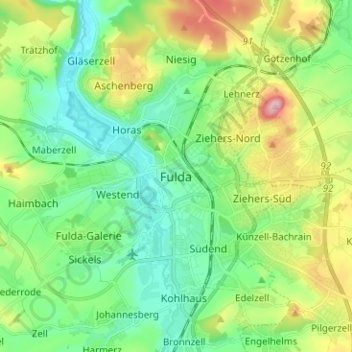
Name: Fulda topographic map, elevation, terrain.
Location: Fulda, Künzell, Landkreis Fulda, Hessen, 36037, Deutschland (50.51423 9.63704 50.59423 9.71704)
Average elevation: 1,004 ft
Minimum elevation: 774 ft
Maximum elevation: 1,526 ft
Make a donation
Gear up for your next adventure:
As an Amazon Associate, this site earns from qualifying purchases at no extra cost to you.
Other topographic maps
Click on a map to view its topography, its elevation and its terrain.
Lehnerz
Deutschland > Hessen > Landkreis Fulda > Fulda
Lehnerz liegt etwa 3,3 km (Luftlinie) nordöstlich der Fuldaer Innenstadt auf dem Nordwesthang des Rauschenberges (471,3 m ü. NHN), auf etwa 300 bis 360 m Höhe (Ortskern 334 m); auf dem zum Großteil zur südsüdöstlich benachbarten Gemeinde Petersberg gehörenden Rauschenberg steht ein Aussichtsturm.…
Average elevation: 1,132 ft
Make a donation
Gear up for your next adventure:
As an Amazon Associate, this site earns from qualifying purchases at no extra cost to you.
Make a donation
Gear up for your next adventure:
As an Amazon Associate, this site earns from qualifying purchases at no extra cost to you.
Istergiesel
Deutschland > Hessen > Landkreis Fulda > Fulda
Istergiesel ist mit seinem Ortsteil Niederröder Höhe ein Stadtteil der osthessischen Stadt Fulda.
Average elevation: 1,102 ft
Make a donation
Gear up for your next adventure:
As an Amazon Associate, this site earns from qualifying purchases at no extra cost to you.