
Eaux-Vives topographic map
Interactive map
Click on the map to display elevation.
About this map
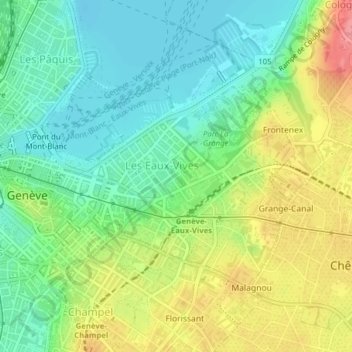
Name: Eaux-Vives topographic map, elevation, terrain.
Location: Eaux-Vives, Genève, Suisse (46.19450 6.15165 46.21189 6.17585)
Average elevation: 1,319 ft
Minimum elevation: 1,207 ft
Maximum elevation: 1,493 ft
Other topographic maps
Click on a map to view its topography, its elevation and its terrain.
Parc Geisendorf
Parc Geisendorf, Grottes et Saint-Gervais, Genève, Suisse
Average elevation: 1,335 ft
Parc des Eaux-Vives
Parc des Eaux-Vives, Eaux-Vives, Genève, Suisse
Average elevation: 1,319 ft
Petit-Saconnex et Servette
Petit-Saconnex et Servette, Genève, 1209, Suisse
Average elevation: 1,398 ft
Grottes et Saint-Gervais
Grottes et Saint-Gervais, Genève, Suisse
Average elevation: 1,322 ft