
Plainpalais topographic map
Interactive map
Click on the map to display elevation.
About this map
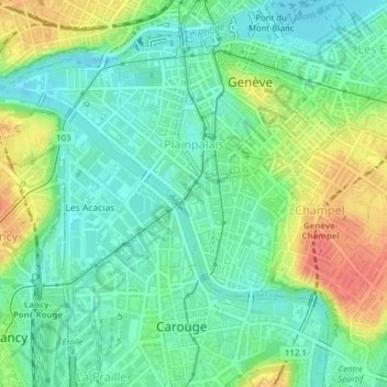
Name: Plainpalais topographic map, elevation, terrain.
Location: Plainpalais, Genève, 1205, Suisse (46.18675 6.13923 46.20108 6.15371)
Average elevation: 1,289 ft
Minimum elevation: 1,214 ft
Maximum elevation: 1,427 ft
Other topographic maps
Click on a map to view its topography, its elevation and its terrain.
Parc Geisendorf
Parc Geisendorf, Grottes et Saint-Gervais, Genève, Suisse
Average elevation: 1,335 ft
Parc des Eaux-Vives
Parc des Eaux-Vives, Eaux-Vives, Genève, Suisse
Average elevation: 1,319 ft
Grottes et Saint-Gervais
Grottes et Saint-Gervais, Genève, Suisse
Average elevation: 1,322 ft
Petit-Saconnex et Servette
Petit-Saconnex et Servette, Genève, 1209, Suisse
Average elevation: 1,398 ft