
Andrews topographic map
Click on the map to display elevation.
Andrews
Until the early 1960s, all Andrews schools were located next to each other on the property of the current elementary school. A 1935 topographic map of Andrews shows each school building, marked with a flag, located adjacent to each other on Walnut Street (now Jean Christy Avenue) and Fourth Street. The current high school and current elementary school appears first in the 1975 map. Between 1935 and 1975, the school zone has dramatically changed.
About this map
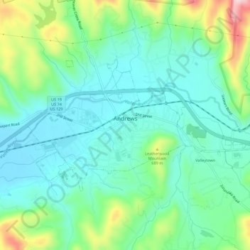
Name: Andrews topographic map, elevation, terrain.
Average elevation: 1,946 ft
Minimum elevation: 1,696 ft
Maximum elevation: 2,631 ft
Cherokee County trails, hiking, mountain biking, running and outdoor activities
Other topographic maps
Click on a map to view its topography, its elevation and its terrain.
Murphy
United States > North Carolina > Cherokee County > Murphy
Murphy is located in southwestern North Carolina, approximately halfway between Atlanta, Georgia and Knoxville, Tennessee. The topography sonsists of gentle rolling hills and mountains with tall peaks, including ranges from 1800 ft to more than 5000 ft elevation. The location in the Blue Ridge Mountains has…
Average elevation: 1,732 ft
Hideaway Mountain Lake Dam
United States > North Carolina > Cherokee County
Average elevation: 2,159 ft
Pleasant Hill
United States > North Carolina > Cherokee County > Pleasant Hill
Average elevation: 1,522 ft