
Topton topographic map
Click on the map to display elevation.
About this map
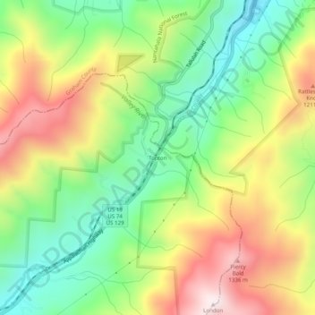
Name: Topton topographic map, elevation, terrain.
Location: Topton, Cherokee County, North Carolina, United States (35.22703 -83.72323 35.26703 -83.68323)
Average elevation: 3,215 ft
Minimum elevation: 2,205 ft
Maximum elevation: 4,554 ft
Cherokee County trails, hiking, mountain biking, running and outdoor activities
Other topographic maps
Click on a map to view its topography, its elevation and its terrain.
Murphy
United States > North Carolina > Cherokee County
Murphy is located in southwestern North Carolina, approximately halfway between Atlanta, Georgia and Knoxville, Tennessee. The topography consists of gentle rolling hills and mountains with tall peaks, including ranges from 1800 ft to more than 5000 ft elevation. The location in the Blue Ridge Mountains has…
Average elevation: 1,690 ft
Murphy
United States > North Carolina > Cherokee County
Murphy has a humid subtropical climate, (Cfa) according to the Köppen classification, with hot, humid summers and cool to mild winters, with low temperatures significantly cooler than other parts of the Southeast, due in part to the elevation. Like the rest of the southeastern U.S., Murphy receives abundant…
Average elevation: 1,690 ft
Andrews
United States > North Carolina > Cherokee County
Until the early 1960s, all Andrews schools were located next to each other on the property of the current elementary school. A 1935 topographic map of Andrews shows each school building, marked with a flag, located adjacent to each other on Walnut Street (now Jean Christy Avenue) and Fourth Street. The current…
Average elevation: 1,946 ft
Murphy
United States > North Carolina > Cherokee County
Murphy is located in southwestern North Carolina, approximately halfway between Atlanta, Georgia and Knoxville, Tennessee. The topography consists of gentle rolling hills and mountains with tall peaks, including ranges from 1800 ft to more than 5000 ft elevation. The location in the Blue Ridge Mountains has…
Average elevation: 1,686 ft
Cherokee County Community
United States > North Carolina > Cherokee County
Average elevation: 2,329 ft