Geolocate

Pag topographic map

Click on the map to display elevation.

About this map

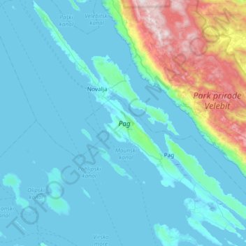
Name: Pag topographic map, elevation, terrain.

Location: Pag, Zadar County, Croatia (44.28908 14.73227 44.70416 15.25962)

Average elevation: 696 ft

Minimum elevation: -23 ft

Maximum elevation: 5,272 ft

Other topographic maps

Click on a map to view its topography, its elevation and its terrain.

Crljenik

Croatia > Zadar County

Average elevation: 505 ft

Bilišane

Croatia > Zadar County > Bilišane

Average elevation: 774 ft

Kaldrma

Croatia > Zadar County > Kaldrma

Average elevation: 2,822 ft

Lovćen

Croatia > Zadar County > Morpolača

Average elevation: 433 ft

Gear up for your next adventure:

📻Weather Alert Radios - Stay informed of storm risks while off-the-grid
🚁Photography Drones - Capture stunning aerial views of landforms and topography
🌡️Portable Weather Meter - Track weather conditions on the trail
🧭Outdoor Navigation Book - Learn advanced navigation skills
👟Men's Trail Runners - Lightweight footwear for fast-paced exploration and light hiking

As an Amazon Associate, this site earns from qualifying purchases at no extra cost to you.