
Narrow Lake topographic map
Click on the map to display elevation.
About this map
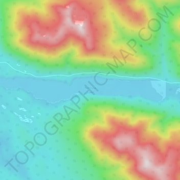
Name: Narrow Lake topographic map, elevation, terrain.
Average elevation: 4,104 ft
Minimum elevation: 3,120 ft
Maximum elevation: 5,968 ft
Other topographic maps
Click on a map to view its topography, its elevation and its terrain.
Willow River
Canada > British Columbia > Regional District of Fraser-Fort George > Area F (Willow River/Upper Fraser)
Average elevation: 2,037 ft
Aleza Lake
Canada > British Columbia > Regional District of Fraser-Fort George > Area F (Willow River/Upper Fraser)
Average elevation: 2,119 ft
Mount St. Patrick
Canada > British Columbia > Regional District of Fraser-Fort George > Area F (Willow River/Upper Fraser)
Average elevation: 7,513 ft
Rocky Mountains
Canada > British Columbia > Regional District of Fraser-Fort George > Area F (Willow River/Upper Fraser)
Average elevation: 4,108 ft
Rocky Mountains
Canada > British Columbia > Regional District of Fraser-Fort George > Area F (Willow River/Upper Fraser)
Average elevation: 4,662 ft
Limestone Lakes
Canada > British Columbia > Regional District of Fraser-Fort George > Area F (Willow River/Upper Fraser)
Average elevation: 5,591 ft
Papoose Lake
Canada > British Columbia > Regional District of Fraser-Fort George > Area F (Willow River/Upper Fraser)
Average elevation: 2,917 ft