
Lebanon topographic map
Interactive map
Click on the map to display elevation.
About this map
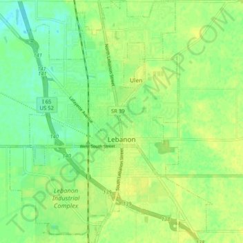
Name: Lebanon topographic map, elevation, terrain.
Location: Lebanon, Boone County, Indiana, 46052, United States (40.02249 -86.50556 40.08295 -86.43940)
Average elevation: 942 ft
Minimum elevation: 909 ft
Maximum elevation: 961 ft
Other topographic maps
Click on a map to view its topography, its elevation and its terrain.
Jamestown
United States > Indiana > Boone County
Jamestown, Boone County, Indiana, United States
Average elevation: 958 ft
Zionsville
United States > Indiana > Boone County
Zionsville, Boone County, Indiana, 46077, United States
Average elevation: 896 ft
Dale
United States > Indiana > Boone County
Dale, Boone County, Indiana, United States
Average elevation: 955 ft
Fayette
United States > Indiana > Boone County > Fayette
Fayette, Boone County, Indiana, United States
Average elevation: 932 ft
Jamestown
United States > Indiana > Boone County > Jamestown
Jamestown, Boone County, Indiana, United States
Average elevation: 958 ft