Geolocate

Eva topographic map

Click on the map to display elevation.

Eva

According to the U.S. Census Bureau, the town of Eva has a total area of 4.3 square miles (11 km2), of which 0.03 square miles (0.08 km2), or 0.74%, are water. The town center, at an elevation of 1,105 feet (337 m) above sea level, is just north of the Tennessee Valley Divide. The town drains west toward Flint Creek and east toward Cotaco Creek, both of which are north-flowing tributaries of the Tennessee River. The southernmost parts of town drain south to Eightmile Creek, a tributary of the Broglen River and part of the Mulberry Fork of the Black Warrior River watershed.

Wikipedia (CC-BY-SA 3.0)

About this map

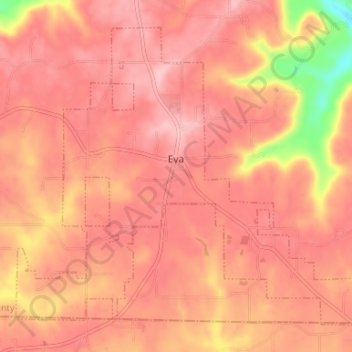
Name: Eva topographic map, elevation, terrain.

Location: Eva, Morgan County, Alabama, United States (34.30656 -86.78903 34.35277 -86.72289)

Average elevation: 1,027 ft

Minimum elevation: 669 ft

Maximum elevation: 1,152 ft

Morgan County trails, hiking, mountain biking, running and outdoor activities

Other topographic maps

Click on a map to view its topography, its elevation and its terrain.

Laceys Spring

United States > Alabama > Morgan County

Average elevation: 699 ft

Decatur

United States > Alabama > Morgan County

Average elevation: 610 ft

Decatur

United States > Alabama > Morgan County > Decatur > Decatur

Average elevation: 623 ft

Florette

United States > Alabama > Morgan County

Average elevation: 666 ft

Basham

United States > Alabama > Morgan County > Decatur

Average elevation: 640 ft

Wolftown

United States > Alabama > Morgan County > Wolftown

Average elevation: 666 ft

Falkville

United States > Alabama > Morgan County

Average elevation: 614 ft

Gear up for your next adventure:

🥤Water Filter Bottle - All‑in‑one filter bottle for safe hydration
🥾Women's Hiking Boots - Top-rated trail boots with ankle support and superior grip
📖Nature Tracking Books - Learn to track wildlife and terrain
🔥Fast-Boil Camping Stoves - Efficient cooking systems for quick trail meals
📌Outdoor GPS Map App - Apps and devices for digital topographic navigation

As an Amazon Associate, this site earns from qualifying purchases at no extra cost to you.