Geolocate

Somal topographic map

Click on the map to display elevation.

About this map

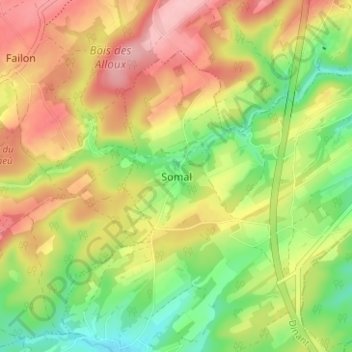
Name: Somal topographic map, elevation, terrain.

Location: Somal, Somme-Leuze, Dinant, Namur, Wallonia, 5374, Belgium (50.30715 5.29965 50.34715 5.33965)

Average elevation: 866 ft

Minimum elevation: 630 ft

Maximum elevation: 1,109 ft

Other topographic maps

Click on a map to view its topography, its elevation and its terrain.

Vresse-sur-Semois

Belgium > Namur > Dinant

Average elevation: 1,076 ft

Anhée

Belgium > Namur > Dinant

Average elevation: 650 ft

Gear up for your next adventure:

🚪Portable Camp Chair - Foldable chair for comfort at camp
🌲Outdoor Survival Books - Best books on survival skills
🍳Camping Cook Set - Complete cookware for outdoor meals
📚Navigation Handbooks - Master the art of reading topographic maps and using a compass
🪑Portable Camp Table - Compact table for campsite meals

As an Amazon Associate, this site earns from qualifying purchases at no extra cost to you.