Geolocate

Lauragh topographic map

Click on the map to display elevation.

About this map

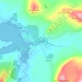
Name: Lauragh topographic map, elevation, terrain.

Location: Lauragh, Kenmare Municipal District, County Kerry, Munster, Ireland (51.74719 -9.78998 51.78719 -9.74998)

Average elevation: 292 ft

Minimum elevation: -13 ft

Maximum elevation: 1,316 ft

Other topographic maps

Click on a map to view its topography, its elevation and its terrain.

Killarney National Park

Ireland > County Kerry

Killarney National Park is in southwest Ireland close to the island's most westerly point. The Lakes of Killarney and the Mangerton, Torc, Shehy and Purple Mountains are in the park. Altitudes in the park range from 22 metres (72 ft) to 842 metres (2,762 ft). A major geological boundary between Devonian Old…

Average elevation: 696 ft

Kenmare

Ireland > County Kerry

Average elevation: 59 ft

Curraglass

Ireland > County Kerry

Average elevation: 472 ft

Sneem

Ireland > County Kerry > Scrahanagaur

Average elevation: 89 ft

Knockdoorah

Ireland > County Kerry

Average elevation: 436 ft

Feale

Ireland > County Kerry

Average elevation: 154 ft

River Laune

Ireland > County Kerry

Average elevation: 144 ft

Maine

Ireland > County Kerry

Average elevation: 249 ft

Lough Leane

Ireland > County Kerry

Average elevation: 364 ft

Doo Lough

Ireland > County Kerry

Average elevation: 66 ft

Valentia Island

Ireland > County Kerry

Average elevation: 128 ft

Great Skellig

Ireland > County Kerry

The island is of special interest to archaeologists, as the monastic settlement is in unusually good condition. The monastery on the northern peak is situated at an elevation of 170 to 180 m (550 to 600 ft), Christ's Saddle at 129 m (422 ft), and the flagstaff area are 37 m (120 ft) above sea level. The…

Average elevation: 3 ft

Little Skellig

Ireland > County Kerry

Average elevation: 0 ft

Dunloe Upper

Ireland > County Kerry

Average elevation: 879 ft

Ballyseedy

Ireland > County Kerry

Average elevation: 69 ft

Dingle Peninsula

Ireland > County Kerry

Average elevation: 246 ft

Killelton

Ireland > County Kerry

Average elevation: 33 ft

Tarbert

Ireland > County Kerry

Average elevation: 72 ft

Carker

Ireland > County Kerry

Average elevation: 502 ft

Knockeenduff

Ireland > County Kerry

Average elevation: 266 ft

Ballinskelligs

Ireland > County Kerry

Average elevation: 46 ft

Kilderry North

Ireland > County Kerry

Average elevation: 89 ft

Dingle Peninsula

Ireland > County Kerry

Average elevation: 246 ft

Killarney National Park

Ireland > County Kerry

Killarney National Park is in southwest Ireland close to the island's most westerly point. The Lakes of Killarney and the Mangerton, Torc, Shehy and Purple Mountains are in the park. Altitudes in the park range from 22 metres (72 ft) to 842 metres (2,762 ft). A major geological boundary between Devonian Old…

Average elevation: 696 ft

Castleisland

Ireland > County Kerry

Average elevation: 108 ft

Lough Currane

Ireland > County Kerry

Average elevation: 190 ft

Ballinrannig

Ireland > County Kerry

Average elevation: 26 ft

Killarney National Park

Ireland > County Kerry

Killarney National Park is in southwest Ireland close to the island's most westerly point. The Lakes of Killarney and the Mangerton, Torc, Shehy and Purple Mountains are in the park. Altitudes in the park range from 22 metres (72 ft) to 842 metres (2,762 ft). A major geological boundary between Devonian Old…

Average elevation: 696 ft

Yellow

Ireland > County Kerry

Average elevation: 686 ft

Beara

Ireland > County Kerry

Average elevation: 354 ft

Clashmelcon

Ireland > County Kerry

Average elevation: 128 ft

Ardoughter

Ireland > County Kerry

Average elevation: 187 ft

Killarney National Park

Ireland > County Kerry

Killarney National Park is in southwest Ireland close to the island's most westerly point. The Lakes of Killarney and the Mangerton, Torc, Shehy and Purple Mountains are in the park. Altitudes in the park range from 22 metres (72 ft) to 842 metres (2,762 ft). A major geological boundary between Devonian Old…

Average elevation: 696 ft

Iveragh

Ireland > County Kerry

Average elevation: 295 ft

Dingle

Ireland > County Kerry

Dingle's St. Mary's is a neo-Gothic church built to designs by J. J. McCarthy and O'Connell. The foundation stone was laid in 1862. It originally had a nave and aisles separated by arcades, supported on columns capped by octagonal tops. The arcades were demolished in one of the most radical reordering schemes…

Average elevation: 135 ft

Listowel

Ireland > County Kerry

Average elevation: 141 ft

Barnastooka

Ireland > County Kerry

Average elevation: 974 ft

Knockalibade

Ireland > County Kerry

Average elevation: 719 ft

Lixnaw

Ireland > County Kerry

Average elevation: 16 ft

Ballyheigue

Ireland > County Kerry

Average elevation: 49 ft

Glanmore

Ireland > County Kerry

Average elevation: 568 ft

Little Skellig

Ireland > County Kerry

Average elevation: 0 ft

Glenlea

Ireland > County Kerry

Average elevation: 200 ft

Rathkenny

Ireland > County Kerry

Average elevation: 131 ft

Sneem

Ireland > County Kerry

Average elevation: 75 ft

Ballybunion

Ireland > County Kerry

Average elevation: 92 ft

Scartaglin

Ireland > County Kerry

Average elevation: 456 ft

Castleisland

Ireland > County Kerry

Average elevation: 108 ft

Sneem

Ireland > County Kerry

Average elevation: 75 ft

Crag

Ireland > County Kerry

Average elevation: 305 ft

Maulyarkane

Ireland > County Kerry

Average elevation: 656 ft

Kenmare

Ireland > County Kerry

Average elevation: 59 ft

Killarney

Ireland > County Kerry

Average elevation: 187 ft

Sneem

Ireland > County Kerry

Average elevation: 75 ft

Cloon

Ireland > County Kerry

Average elevation: 82 ft

Boolacullane

Ireland > County Kerry

Average elevation: 371 ft

Tralee

Ireland > County Kerry

Average elevation: 75 ft

Ballinskelligs

Ireland > County Kerry

Average elevation: 46 ft

Tralee

Ireland > County Kerry

Average elevation: 72 ft

Ballyseedy Wood

Ireland > County Kerry

Average elevation: 66 ft

Beara

Ireland > County Kerry

Average elevation: 354 ft

Ballyspillane

Ireland > County Kerry > Killarney

Average elevation: 233 ft

Listowel

Ireland > County Kerry

Average elevation: 141 ft

Kenmare

Ireland > County Kerry

Average elevation: 59 ft

Ballylongford

Ireland > County Kerry

Average elevation: 49 ft

Rathmore

Ireland > County Kerry

Average elevation: 489 ft

Listowel

Ireland > County Kerry

Average elevation: 141 ft

Cahersiveen

Ireland > County Kerry

Average elevation: 217 ft

Kilcummin

Ireland > County Kerry

Average elevation: 466 ft

Brosna

Ireland > County Kerry

Average elevation: 535 ft

Killarney

Ireland > County Kerry

Average elevation: 187 ft

Dingle

Ireland > County Kerry

Dingle's St. Mary's is a neo-Gothic church built to designs by J. J. McCarthy and O'Connell. The foundation stone was laid in 1862. It originally had a nave and aisles separated by arcades, supported on columns capped by octagonal tops. The arcades were demolished in one of the most radical reordering schemes…

Average elevation: 135 ft

Kilgarvan

Ireland > County Kerry

Average elevation: 233 ft

Tralee

Ireland > County Kerry

Average elevation: 66 ft

Lyreboy

Ireland > County Kerry

Average elevation: 1,122 ft

Killarney

Ireland > County Kerry

Average elevation: 128 ft

Killorglin

Ireland > County Kerry

Average elevation: 75 ft

Cromane Upper

Ireland > County Kerry

Average elevation: 59 ft

Great Skellig

Ireland > County Kerry

Skellig Michael consists of approximately 22 hectares (54 acres) of rock, with its highest point, known as the Spit, 218 m (714 ft) above sea level. The island is defined by its twin peaks and intervening valley (known as Christ's Saddle), which make its landscape steep and inhospitable. It is best known for…

Average elevation: 3 ft

Ballybunion

Ireland > County Kerry

Average elevation: 92 ft

Listowel

Ireland > County Kerry

Average elevation: 141 ft

Killarney

Ireland > County Kerry

Average elevation: 187 ft

Killarney

Ireland > County Kerry

Average elevation: 187 ft

Staigue Fort

Ireland > County Kerry

Average elevation: 627 ft

Banna Strand

Ireland > County Kerry

Average elevation: 13 ft

Glanmore

Ireland > County Kerry

Average elevation: 614 ft

Beheenagh

Ireland > County Kerry

Average elevation: 1,138 ft

Kenmare Municipal District

Ireland > County Kerry

Average elevation: 322 ft

Killarney

Ireland > County Kerry

Average elevation: 187 ft

Cloghanecarhan

Ireland > County Kerry

Average elevation: 659 ft

Lickeen

Ireland > County Kerry

Average elevation: 177 ft

Kenmare Municipal District

Ireland > County Kerry

Average elevation: 322 ft

Tralee Municipal District

Ireland > County Kerry

Average elevation: 364 ft

Dunloe ED

Ireland > County Kerry

Average elevation: 702 ft

Crosstown

Ireland > County Kerry

Average elevation: 354 ft

Aghadoe

Ireland > County Kerry

Average elevation: 433 ft

Gear up for your next adventure:

🔥Camping Stove - Portable stove for camping and backcountry cooking
📦Gear Storage Bags - Organize and protect outdoor equipment
📖Nature Tracking Books - Learn to track wildlife and terrain
📡Handheld GPS Device - Reliable handheld GPS for outdoor navigation
🏫Relief Map Kits - Hands-on tools for teaching landforms and elevation

As an Amazon Associate, this site earns from qualifying purchases at no extra cost to you.