Geolocate

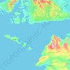
Beara topographic map

Click on the map to display elevation.

About this map
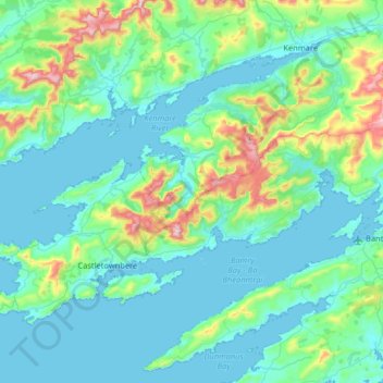
Name: Beara topographic map, elevation, terrain.

Location: Beara, County Cork, Munster, Ireland (51.58116 -10.16216 51.87505 -9.51441)

Average elevation: 354 ft

Minimum elevation: -3 ft

Maximum elevation: 2,395 ft

Other topographic maps

Click on a map to view its topography, its elevation and its terrain.

Great Skellig

Ireland > County Kerry

Skellig Michael consists of approximately 22 hectares (54 acres) of rock, with its highest point, known as the Spit, 218 m (714 ft) above sea level. The island is defined by its twin peaks and intervening valley (known as Christ's Saddle), which make its landscape steep and inhospitable. It is best known for…

Average elevation: 3 ft
Mullaghmore

Ireland > County Clare

Average elevation: 200 ft

Curracloe

Ireland > County Wexford

Average elevation: 69 ft

Killaloe

Ireland > County Clare

Average elevation: 203 ft
Lisgoold

Ireland > County Cork

Average elevation: 367 ft

Claregalway

Ireland > County Galway

Average elevation: 52 ft

Rine River

Ireland > County Clare

Average elevation: 20 ft

Kilkee Cliffs

Ireland > County Clare

Average elevation: 62 ft

Spink

Ireland > County Laois

Average elevation: 719 ft

Mitchelstown

Ireland > County Cork > Mitchelstown

Average elevation: 417 ft

Macroom

Ireland > County Cork > Blarney - Macroom > Macroom

Average elevation: 377 ft

Gurteen

Ireland > County Galway

Average elevation: 292 ft

Costelloe

Ireland > County Galway

Average elevation: 39 ft

Doolin

Ireland > County Clare

Average elevation: 174 ft

Glassilaun Beach

Ireland > County Galway

Average elevation: 36 ft

Halfway

Ireland > County Cork

Average elevation: 315 ft

White River

Ireland > County Louth

Average elevation: 246 ft

Kiltegan

Ireland > County Wicklow

Average elevation: 492 ft

Model Village

Ireland > County Cork

Average elevation: 328 ft

Minane Bridge

Ireland > County Cork

Average elevation: 230 ft

Horseleap

Ireland > County Offaly

Average elevation: 230 ft

Mullingar

Ireland > County Westmeath

Average elevation: 331 ft

Inch

Ireland > County Wexford

Average elevation: 157 ft

Brick

Ireland > County Kerry

Average elevation: 16 ft

Croaghaun

Ireland > County Mayo

Average elevation: 902 ft

Keshcarrigan

Ireland > County Leitrim

Average elevation: 256 ft

Galway Bay

Ireland > County Galway

Average elevation: 115 ft

Mahon Falls

Ireland > County Waterford

Average elevation: 1,886 ft

Derryclare

Ireland > County Galway

Average elevation: 915 ft

Kilconnell

Ireland > County Galway

Average elevation: 302 ft

Ring Hill

Ireland > County Tipperary

Average elevation: 1,033 ft

Saint Catherines

Ireland > County Donegal

Average elevation: 82 ft

Alder

Ireland > County Dublin > Goatstown

Average elevation: 187 ft

Boston

Ireland > County Clare

Average elevation: 82 ft

Westport

Ireland > County Mayo > Westport

Average elevation: 131 ft

Crotty's Rock

Ireland > County Waterford

Average elevation: 1,391 ft

Mulhuddart

Ireland

Average elevation: 220 ft

Leamlara

Ireland > County Cork

Average elevation: 476 ft

Kilmichael

Ireland > County Cork

Average elevation: 436 ft

Red Island

Ireland > County Cavan > Carrickclevan

Average elevation: 249 ft

Knock

Ireland > County Clare

Average elevation: 69 ft

Bettystown

Ireland > County Meath

Average elevation: 20 ft

Ballyogan

Ireland > County Dublin

Average elevation: 381 ft

Upper Lake

Ireland > County Wicklow

Average elevation: 1,086 ft

Gear up for your next adventure:

🏕️Family Camping Gear - Essentials for group camping trips
🪑Portable Camp Table - Compact table for campsite meals
🧦Merino Wool Socks - Moisture-wicking, blister-preventing socks for long treks
🌲Outdoor Survival Books - Best books on survival skills
❄️Traction Cleats - Prevent slips on icy trails during winter hikes

As an Amazon Associate, this site earns from qualifying purchases at no extra cost to you.