Geolocate

Marston topographic map

Click on the map to display elevation.

About this map

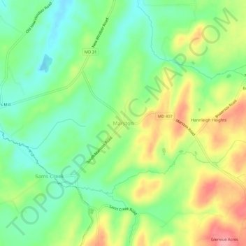
Name: Marston topographic map, elevation, terrain.

Location: Marston, Carroll County, Maryland, 21776, United States (39.48788 -77.12026 39.52788 -77.08026)

Average elevation: 620 ft

Minimum elevation: 469 ft

Maximum elevation: 843 ft

Carroll County trails, hiking, mountain biking, running and outdoor activities

Other topographic maps

Click on a map to view its topography, its elevation and its terrain.

Taneytown

United States > Maryland > Carroll County

Average elevation: 502 ft

Union Bridge

United States > Maryland > Carroll County

Average elevation: 453 ft

Eldersburg

United States > Maryland > Carroll County > Eldersburg

Average elevation: 548 ft

Gear up for your next adventure:

⛑️Personal Locator Beacon - Safety beacon for emergencies
🪶Camp Gear Gift Set - Perfect gift bundle for outdoor fans
🪶Wildlife Field Guides - Learn animal tracking and species ID
🎒Day Hiking Backpack - Lightweight backpack perfect for day trips and outdoor adventures
Solar GPS Watches - Advanced multisport watches with built-in topographic maps

As an Amazon Associate, this site earns from qualifying purchases at no extra cost to you.