
Erlangen topographic map
Click on the map to display elevation.
About this map
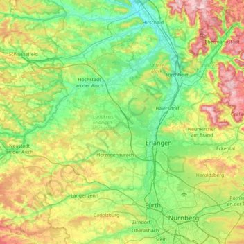
Name: Erlangen topographic map, elevation, terrain.
Location: Erlangen, Landkreis Erlangen-Höchstadt, Bayern, Deutschland (49.47310 10.59191 49.78825 11.28857)
Average elevation: 1,112 ft
Minimum elevation: 784 ft
Maximum elevation: 1,890 ft
Other topographic maps
Click on a map to view its topography, its elevation and its terrain.
Adlitz
Deutschland > Bayern > Landkreis Erlangen-Höchstadt
Das Dorf liegt am nördlichen Hang des Höhenzuges von Rathsberg nach Marloffstein. Unmittelbar ist der Ort von Acker- und Grünland umgeben. Etwas weiter westlich und östlich befinden sich Waldgebiete, das östliche wird Bergholz genannt. Durch diese Waldgebiete fließen zwei namenlose Bäche, die in…
Average elevation: 1,089 ft
Büg
Deutschland > Bayern > Landkreis Erlangen-Höchstadt > Eckental > Forth
Average elevation: 1,119 ft
Hauptendorf
Deutschland > Bayern > Landkreis Erlangen-Höchstadt > Herzogenaurach
Average elevation: 1,050 ft
Oberschöllenbach
Deutschland > Bayern > Landkreis Erlangen-Höchstadt > Eckental
Average elevation: 1,145 ft
Eckental
Deutschland > Bayern > Landkreis Erlangen-Höchstadt > Eckental > Eckental
Average elevation: 1,184 ft
Höchstadt an der Aisch
Deutschland > Bayern > Landkreis Erlangen-Höchstadt > Höchstadt a.d.Aisch > Höchstadt an der Aisch
Average elevation: 971 ft
Lappach
Deutschland > Bayern > Landkreis Erlangen-Höchstadt > Höchstadt a.d.Aisch
Average elevation: 958 ft
Zweifelsheim
Deutschland > Bayern > Landkreis Erlangen-Höchstadt > Herzogenaurach
Average elevation: 1,188 ft
Zentbechhofen
Deutschland > Bayern > Landkreis Erlangen-Höchstadt > Höchstadt an der Aisch
Average elevation: 994 ft
Rathsberg
Deutschland > Bayern > Landkreis Erlangen-Höchstadt
Der Ort und das gleichnamige Schloss Rathsberg liegen auf dem höchsten, westlichen Punkt des gleichnamigen Höhenzugs Rathsberg nordöstlich von Erlangen.
Average elevation: 1,007 ft
Beutelsdorf
Deutschland > Bayern > Landkreis Erlangen-Höchstadt > Herzogenaurach
Average elevation: 1,070 ft
Herzogenaurach
Deutschland > Bayern > Landkreis Erlangen-Höchstadt > Herzogenaurach
Average elevation: 1,079 ft
Atzelsberg
Deutschland > Bayern > Landkreis Erlangen-Höchstadt > Atzelsberg
Average elevation: 1,050 ft
Jungenhofen
Deutschland > Bayern > Landkreis Erlangen-Höchstadt > Höchstadt a.d.Aisch
Average elevation: 994 ft
Burgstall
Deutschland > Bayern > Landkreis Erlangen-Höchstadt > Herzogenaurach
Average elevation: 1,099 ft
Kleinseebach
Deutschland > Bayern > Landkreis Erlangen-Höchstadt > Kleinseebach
Average elevation: 932 ft