
Copper River topographic map
Click on the map to display elevation.
About this map
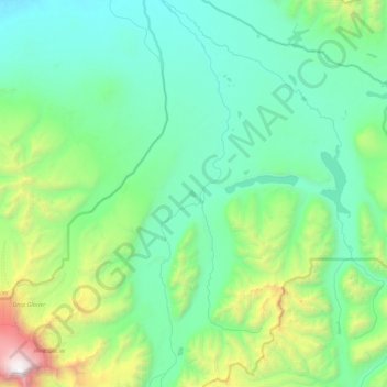
Name: Copper River topographic map, elevation, terrain.
Location: Copper River, Alaska, United States (62.19714 -143.79991 62.61959 -143.63435)
Average elevation: 4,370 ft
Minimum elevation: 2,185 ft
Maximum elevation: 16,204 ft
Copper River trails, hiking, mountain biking, running and outdoor activities
Other topographic maps
Click on a map to view its topography, its elevation and its terrain.
Kennicott
United States > Alaska > Copper River
Topographic map showing the location of the Erie, Jumbo, Mother Lode, Bonanza and Glacier Mines in relation to Kennecott. Note the aerial tramways and haulage tunnels.
Average elevation: 2,589 ft