
Make a donation
Gear up for your next adventure:
As an Amazon Associate, this site earns from qualifying purchases at no extra cost to you.
Amargosa Valley topographic map
Click on the map to display elevation.
Make a donation
Gear up for your next adventure:
As an Amazon Associate, this site earns from qualifying purchases at no extra cost to you.
Amargosa Valley
Amargosa Valley is located at 36.58001 North, 116.44487 West at an elevation of 2,640 feet (805 m) above sea level. The landscape is typical of lower to moderate elevations in the Mojave Desert, with flat expanses of sandy soil punctuated by rocky mounds and hills. Predominant indigenous vegetation is White Bursage and Creosote Bush, with some Joshua Trees and Cacti at higher elevations. Numerous non-native plant species have also been introduced.
Make a donation
Gear up for your next adventure:
As an Amazon Associate, this site earns from qualifying purchases at no extra cost to you.
About this map
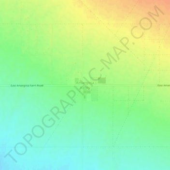
Name: Amargosa Valley topographic map, elevation, terrain.
Location: Amargosa Valley, Nye County, Nevada, United States (36.54899 -116.48122 36.58899 -116.44122)
Average elevation: 2,428 ft
Minimum elevation: 2,372 ft
Maximum elevation: 2,490 ft
Nye County trails, hiking, mountain biking, running and outdoor activities
Make a donation
Gear up for your next adventure:
As an Amazon Associate, this site earns from qualifying purchases at no extra cost to you.
Other topographic maps
Click on a map to view its topography, its elevation and its terrain.
Pahrump
United States > Nevada > Nye County
Summers in Pahrump are generally very hot and dry, with occasional pushes of monsoonal moisture beginning in early July. Being at a similar elevation to Las Vegas, daytime highs in summer average within a few degrees lower than that of Las Vegas. Record highs are similar between the two cities as well. A…
Average elevation: 3,747 ft
Tonopah
United States > Nevada > Nye County
Tonopah has an arid, cold desert climate with cool winters and hot summers. Due to Tonopah’s aridity and high altitude, daily temperature ranges are quite large and lows in winter are similar to many continental climates. Nights are cool, even in summer.
Average elevation: 6,043 ft
Make a donation
Gear up for your next adventure:
As an Amazon Associate, this site earns from qualifying purchases at no extra cost to you.
Tonopah
United States > Nevada > Nye County
Tonopah has an arid, cold desert climate with cool winters and hot summers. Due to Tonopah’s aridity and high altitude, daily temperature ranges are quite large and lows in winter are similar to many continental climates. Nights are cool, even in summer.
Average elevation: 6,043 ft
Pahrump
United States > Nevada > Nye County
Summers in Pahrump are generally very hot and dry, with occasional pushes of monsoonal moisture beginning in early July. Being at a similar elevation to Las Vegas, daytime highs in summer average within a few degrees lower than that of Las Vegas. Record highs are similar between the two cities as well. A…
Average elevation: 3,743 ft
Make a donation
Gear up for your next adventure:
As an Amazon Associate, this site earns from qualifying purchases at no extra cost to you.