
Beatty topographic map
Click on the map to display elevation.
About this map
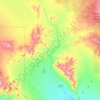
Name: Beatty topographic map, elevation, terrain.
Location: Beatty, Nye County, Nevada, 89003, United States (36.74182 -116.82088 37.11714 -116.58894)
Average elevation: 4,045 ft
Minimum elevation: 2,697 ft
Maximum elevation: 6,257 ft
Nye County trails, hiking, mountain biking, running and outdoor activities
Other topographic maps
Click on a map to view its topography, its elevation and its terrain.
Amargosa Valley
United States > Nevada > Nye County
Amargosa Valley is located at 36.58001 North, 116.44487 West at an elevation of 2,640 feet (805 m) above sea level. The landscape is typical of lower to moderate elevations in the Mojave Desert, with flat expanses of sandy soil punctuated by rocky mounds and hills. Predominant indigenous vegetation is White…
Average elevation: 2,428 ft
Devils Hole
United States > Nevada > Nye County
Devils Hole is a geothermal pool within a limestone cavern in the Amargosa Desert in the Amargosa Valley of Nevada, east over the Amargosa Range and Funeral Mountains from Death Valley. It is at an elevation of 730 m (2,400 ft) above sea level and the water is a constant temperature of 33 °C (91 °F). The…
Average elevation: 2,480 ft