
Make a donation
Gear up for your next adventure:
As an Amazon Associate, this site earns from qualifying purchases at no extra cost to you.
Beaver Island topographic map
Click on the map to display elevation.
Make a donation
Gear up for your next adventure:
As an Amazon Associate, this site earns from qualifying purchases at no extra cost to you.
Beaver Island
Other islands in the group include Staats Island, with an area of 500 hectares (1,200 acres); Tea Island, which covers 310 hectares (770 acres); Governor Island, which covers 220 hectares (540 acres); Split Island, with an area of 70 hectares (170 acres) and a few smaller islands. Though the smaller islands in the group are low-lying, the larger islands are very hilly, with many peaks of more than 150 metres (490 ft) and some more than 200 metres (660 ft). The highest elevation in the Beaver Island Group is 234 metres (768 ft).
Make a donation
Gear up for your next adventure:
As an Amazon Associate, this site earns from qualifying purchases at no extra cost to you.
About this map
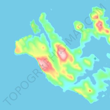
Name: Beaver Island topographic map, elevation, terrain.
Location: Beaver Island, Falkland Islands (-51.87863 -61.34800 -51.79528 -61.19575)
Average elevation: 79 ft
Minimum elevation: -3 ft
Maximum elevation: 781 ft
Make a donation
Gear up for your next adventure:
As an Amazon Associate, this site earns from qualifying purchases at no extra cost to you.
Other topographic maps
Click on a map to view its topography, its elevation and its terrain.
Make a donation
Gear up for your next adventure:
As an Amazon Associate, this site earns from qualifying purchases at no extra cost to you.