
Make a donation
Gear up for your next adventure:
As an Amazon Associate, this site earns from qualifying purchases at no extra cost to you.
Lively Island topographic map
Click on the map to display elevation.
Make a donation
Gear up for your next adventure:
As an Amazon Associate, this site earns from qualifying purchases at no extra cost to you.
About this map
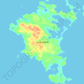
Name: Lively Island topographic map, elevation, terrain.
Location: Lively Island, Falkland Islands (-52.10247 -58.55435 -51.98781 -58.39402)
Average elevation: 16 ft
Minimum elevation: -3 ft
Maximum elevation: 128 ft
Make a donation
Gear up for your next adventure:
As an Amazon Associate, this site earns from qualifying purchases at no extra cost to you.
Other topographic maps
Click on a map to view its topography, its elevation and its terrain.
Beaver Island
Other islands in the group include Staats Island, with an area of 500 hectares (1,200 acres); Tea Island, which covers 310 hectares (770 acres); Governor Island, which covers 220 hectares (540 acres); Split Island, with an area of 70 hectares (170 acres) and a few smaller islands. Though the smaller islands in…
Average elevation: 79 ft
Make a donation
Gear up for your next adventure:
As an Amazon Associate, this site earns from qualifying purchases at no extra cost to you.