Geolocate

Caticlan topographic map

Click on the map to display elevation.

About this map

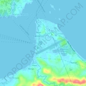
Name: Caticlan topographic map, elevation, terrain.

Location: Caticlan, Malay, Aklan, Western Visayas, 5608, Philippines (11.91048 121.93114 11.95048 121.97114)

Average elevation: 26 ft

Minimum elevation: -3 ft

Maximum elevation: 312 ft

Other topographic maps

Click on a map to view its topography, its elevation and its terrain.

Potol

Philippines > Aklan > Malay > Argao > Potol

Average elevation: 92 ft

Boracay

Philippines > Aklan > Malay > Caticlan

Average elevation: 20 ft

Punta Bunga Beach

Philippines > Aklan > Malay

Average elevation: 52 ft

Ilig Iligan Beach

Philippines > Aklan > Malay

Average elevation: 43 ft

Boracay

Philippines > Aklan > Malay

Average elevation: 20 ft

Boracay

Philippines > Aklan > Malay

Average elevation: 20 ft

Boracay

Philippines > Aklan > Malay

Average elevation: 20 ft

Boracay

Philippines > Aklan > Malay > Caticlan

Average elevation: 20 ft

Manoc-Manoc

Philippines > Aklan > Malay

Average elevation: 16 ft

Gear up for your next adventure:

🔭Compact Binoculars - HD vision for scouting terrain and identifying distant landmarks
GPS Sports Watch - GPS watch for running, hiking and training
🌐World Map Poster - Decorative world maps with topographic info
🪶Fire Starter Kit - Reliable fire starter for survival and camping
🥤Water Filter Bottle - All‑in‑one filter bottle for safe hydration

As an Amazon Associate, this site earns from qualifying purchases at no extra cost to you.