Geolocate

Boracay topographic map

Click on the map to display elevation.

About this map

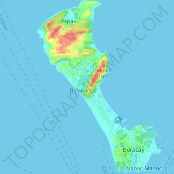
Name: Boracay topographic map, elevation, terrain.

Location: Boracay, Malay, Aklan, Western Visayas, Philippines (11.93926 121.90499 11.99942 121.94933)

Average elevation: 20 ft

Minimum elevation: 0 ft

Maximum elevation: 299 ft

Other topographic maps

Click on a map to view its topography, its elevation and its terrain.

Potol

Philippines > Aklan > Malay > Argao > Potol

Average elevation: 92 ft

Nabaoy

Philippines > Aklan > Malay

Average elevation: 305 ft

Nabaoy

Philippines > Aklan > Malay

Average elevation: 289 ft

Naasug

Philippines > Aklan > Malay

Average elevation: 184 ft

Banga

Philippines > Aklan > Malay > Argao

Average elevation: 89 ft

Punta Bunga Beach

Philippines > Aklan > Malay

Average elevation: 52 ft

Ilig Iligan Beach

Philippines > Aklan > Malay

Average elevation: 43 ft

Mount Luho

Philippines > Aklan > Malay

Average elevation: 46 ft

Caticlan

Philippines > Aklan > Malay

Average elevation: 26 ft

Tabon

Philippines > Aklan > Malay > Union

Average elevation: 20 ft

Mount Luho

Philippines > Aklan > Malay

Average elevation: 46 ft

Chalung

Philippines > Aklan > Malay > Cubay Sur

Average elevation: 82 ft

Gear up for your next adventure:

🪶Camping Sleeping Pad - Comfortable sleeping pad for backpacking
🛶Inflatable Kayak - Portable kayak for rivers, lakes, and expeditions
🏔️Mountain Trail Maps - High‑detail maps for popular peaks
🧭Orienteering Set - Complete compass and map reading kit
🧢Outdoor Hiking Hat - Sun protection hat for outdoor explorers

As an Amazon Associate, this site earns from qualifying purchases at no extra cost to you.