
Make a donation
Gear up for your next adventure:
As an Amazon Associate, this site earns from qualifying purchases at no extra cost to you.
Daniel Campos topographic map
Click on the map to display elevation.
Make a donation
Gear up for your next adventure:
As an Amazon Associate, this site earns from qualifying purchases at no extra cost to you.
About this map
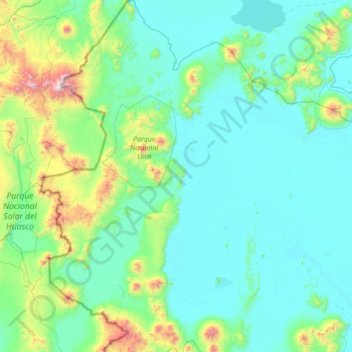
Name: Daniel Campos topographic map, elevation, terrain.
Location: Daniel Campos, Potosí, Bolivia (-20.71027 -68.77382 -19.43624 -67.54518)
Average elevation: 12,841 ft
Minimum elevation: 11,959 ft
Maximum elevation: 19,511 ft
Make a donation
Gear up for your next adventure:
As an Amazon Associate, this site earns from qualifying purchases at no extra cost to you.
Other topographic maps
Click on a map to view its topography, its elevation and its terrain.
San Marcos
Bolivia > Potosí > Provincia Modesto Omiste > Villazón > San Marcos
Average elevation: 10,030 ft
Make a donation
Gear up for your next adventure:
As an Amazon Associate, this site earns from qualifying purchases at no extra cost to you.
Villa Santa Ana
Bolivia > Potosí > Provincia General Bernardino Bilbao Rioja > Municipio Acasio > Villa Santa Ana
Average elevation: 10,030 ft
Make a donation
Gear up for your next adventure:
As an Amazon Associate, this site earns from qualifying purchases at no extra cost to you.
Laguna Colorada
Bolivia > Potosí > Provincia Sur Lípez > Municipio San Pablo de Lipez
Average elevation: 14,114 ft