
Make a donation
Gear up for your next adventure:
As an Amazon Associate, this site earns from qualifying purchases at no extra cost to you.
Püttlach topographic map
Click on the map to display elevation.
Make a donation
Gear up for your next adventure:
As an Amazon Associate, this site earns from qualifying purchases at no extra cost to you.
About this map
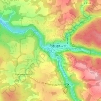
Name: Püttlach topographic map, elevation, terrain.
Average elevation: 1,407 ft
Minimum elevation: 1,138 ft
Maximum elevation: 1,621 ft
Make a donation
Gear up for your next adventure:
As an Amazon Associate, this site earns from qualifying purchases at no extra cost to you.
Other topographic maps
Click on a map to view its topography, its elevation and its terrain.
Kühlenfels
Deutschland > Bayern > Landkreis Bayreuth > Pottenstein
Altenhof | Arnleithen | Elbersberg | Geusmanns | Graisch | Haselbrunn | Haßlach | Hohenmirsberg | Kirchenbirkig | Kleinkirchenbirkig | Kleinlesau | Kühlenfels | Leienfels | Mandlau | Mittelmühle | Neu-Geusmanns | Pottenstein | Prüllsbirkig | Pullendorf | Püttlach | Rackersberg | Regenthal |…
Average elevation: 1,519 ft
Kleinlesau
Deutschland > Bayern > Landkreis Bayreuth > Pottenstein > Rackersberg
Altenhof | Arnleithen | Elbersberg | Geusmanns | Graisch | Haselbrunn | Haßlach | Hohenmirsberg | Kirchenbirkig | Kleinkirchenbirkig | Kleinlesau | Kühlenfels | Leienfels | Mandlau | Mittelmühle | Neu-Geusmanns | Pottenstein | Prüllsbirkig | Pullendorf | Püttlach | Rackersberg | Regenthal |…
Average elevation: 1,414 ft
Regenthal
Deutschland > Bayern > Landkreis Bayreuth > Pottenstein
Altenhof | Arnleithen | Elbersberg | Geusmanns | Graisch | Haselbrunn | Haßlach | Hohenmirsberg | Kirchenbirkig | Kleinkirchenbirkig | Kleinlesau | Kühlenfels | Leienfels | Mandlau | Mittelmühle | Neu-Geusmanns | Pottenstein | Prüllsbirkig | Pullendorf | Püttlach | Rackersberg | Regenthal |…
Average elevation: 1,631 ft