Geolocate

Steinkjer topographic map

Click on the map to display elevation.

About this map

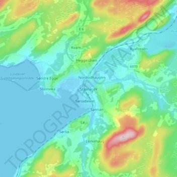
Name: Steinkjer topographic map, elevation, terrain.

Location: Steinkjer, Trøndelag, 7714, Norway (63.97518 11.45566 64.05518 11.53566)

Average elevation: 243 ft

Minimum elevation: -3 ft

Maximum elevation: 1,099 ft

Other topographic maps

Click on a map to view its topography, its elevation and its terrain.

Inderøy

Norway > Trøndelag

Average elevation: 509 ft

Selbu

Norway > Trøndelag

Average elevation: 1,801 ft

Stjørdal

Norway > Trøndelag

Average elevation: 1,030 ft

Verdal

Norway > Trøndelag

Average elevation: 1,319 ft

Austra

Norway > Trøndelag

Average elevation: 318 ft

Herøya

Norway > Trøndelag

Average elevation: 7 ft

Gear up for your next adventure:

🦟Ultrasonic Repellers - Create a bug-free zone at your camp or rest stop
🔋Rechargeable Batteries - Power up your outdoor devices
🧤Hiking Gloves - Protective gloves for rugged trails
🛏️Cold Weather Sleeping Bag - Warm sleeping bag for cold conditions
🪶Fire Starter Kit - Reliable fire starter for survival and camping

As an Amazon Associate, this site earns from qualifying purchases at no extra cost to you.