Geolocate

Verdal topographic map

Click on the map to display elevation.

About this map

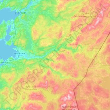
Name: Verdal topographic map, elevation, terrain.

Location: Verdal, Trøndelag, Norway (63.59342 11.33192 63.97422 12.68357)

Average elevation: 1,319 ft

Minimum elevation: -3 ft

Maximum elevation: 4,049 ft

Other topographic maps

Click on a map to view its topography, its elevation and its terrain.

Hell

Norway > Trøndelag

Average elevation: 167 ft

Tulluan

Norway > Trøndelag > Trondheim

Average elevation: 633 ft

Tomset

Norway > Trøndelag > Trondheim

Average elevation: 554 ft

Røros

Norway > Trøndelag

Average elevation: 2,316 ft

Rørvika

Norway > Trøndelag

Average elevation: 272 ft

Gimse

Norway > Trøndelag > Gimse

Average elevation: 249 ft

Steinkjer

Norway > Trøndelag

Average elevation: 243 ft

Herøya

Norway > Trøndelag

Average elevation: 7 ft

Gear up for your next adventure:

🗺️NatGeo Topo Maps - High-quality waterproof printed topographic maps of US Parks
🏥Hiking First Aid Kits - Comprehensive medical kits for remote trail injuries
🧯Portable Fire Pit - Compact fire pit for camping spots
🎒Day Hiking Backpack - Lightweight backpack perfect for day trips and outdoor adventures
🦶Hiking Gaiters - Keep debris and water out of your boots

As an Amazon Associate, this site earns from qualifying purchases at no extra cost to you.