Geolocate

Upwaltham topographic map

Click on the map to display elevation.

Upwaltham

The Skytrain was from the 27th Transport Group. On 11 February 1945 it was on a flight from Paris–Le Bourget Airport to RAF Grove in Berkshire. It crossed the Sussex coast about 1125 hrs at an altitude of only 300 to 400 feet (91 to 122 m). The weather was worsening, visibility had decreased to 25 yards (23 m), and the crew may not have realised they were no longer over the sea. The aircraft's port wing hit trees on Upwaltham Hill and was torn off. The aircraft seems to have cartwheeled before breaking up. All seven men aboard were killed.

Wikipedia (CC-BY-SA 3.0)

About this map

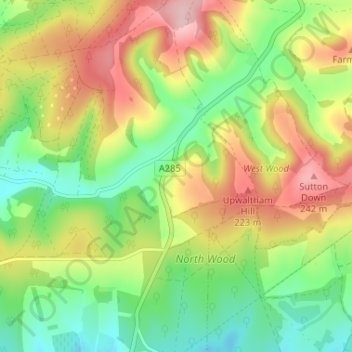
Name: Upwaltham topographic map, elevation, terrain.

Location: Upwaltham, Chichester, West Sussex, England, United Kingdom (50.88800 -0.67891 50.92894 -0.64779)

Average elevation: 499 ft

Minimum elevation: 246 ft

Maximum elevation: 833 ft

Other topographic maps

Click on a map to view its topography, its elevation and its terrain.

North Marden

United Kingdom > England > West Sussex > Chichester

Average elevation: 459 ft

Nutbourne

United Kingdom > England > West Sussex > Chichester

Average elevation: 23 ft

Bracklesham

United Kingdom > England > West Sussex > Chichester

Average elevation: 7 ft

Charlton

United Kingdom > England > West Sussex > Chichester

Average elevation: 384 ft

Hammer

United Kingdom > England > West Sussex > Chichester

Average elevation: 522 ft

Highleigh

United Kingdom > England > West Sussex > Chichester

Average elevation: 13 ft

Titty Hill

United Kingdom > England > West Sussex > Chichester

Average elevation: 285 ft

Bexley Hill

United Kingdom > England > West Sussex > Chichester

Average elevation: 338 ft

West Burton

United Kingdom > England > West Sussex > Chichester

Average elevation: 171 ft

West Harting

United Kingdom > England > West Sussex > Chichester

Average elevation: 233 ft

South Ambersham

United Kingdom > England > West Sussex > Chichester

Average elevation: 131 ft

Adsdean Down

United Kingdom > England > West Sussex > Chichester > Stoughton

Average elevation: 285 ft

Blackdown

United Kingdom > England > West Sussex > Chichester

Blackdown, or Black Down, summit elevation 279.7 metres (918 ft) AMSL, is the highest point in both the historic county of Sussex and the South Downs National Park. It is one of the highest points in the south east of England, exceeded by Walbury Hill, Leith Hill and Pilot Hill. Blackdown is protected as part…

Average elevation: 541 ft

East Lavant

United Kingdom > England > West Sussex > Chichester > Lavant

Average elevation: 151 ft

West Stoke

United Kingdom > England > West Sussex > Chichester

Average elevation: 177 ft

Haye's Down

United Kingdom > England > West Sussex > Chichester

Average elevation: 282 ft

East Harting

United Kingdom > England > West Sussex > Chichester

Average elevation: 302 ft

West Lavant

United Kingdom > England > West Sussex > Chichester > Lavant

Average elevation: 148 ft

Harting Down

United Kingdom > England > West Sussex > Chichester

Average elevation: 449 ft

River Lavant

United Kingdom > England > West Sussex > Chichester

Average elevation: 43 ft

Loxwood

United Kingdom > England > West Sussex > Chichester

Average elevation: 115 ft

Halnaker

United Kingdom > England > West Sussex > Chichester

Average elevation: 154 ft

East Ashling

United Kingdom > England > West Sussex > Chichester

Average elevation: 128 ft

South Harting

United Kingdom > England > West Sussex > Chichester

Average elevation: 358 ft

Upperton

United Kingdom > England > West Sussex > Chichester > Tillington

Average elevation: 167 ft

Up Marden

United Kingdom > England > West Sussex > Chichester

Average elevation: 354 ft

Prinsted

United Kingdom > England > West Sussex > Chichester

Average elevation: 20 ft

Redford

United Kingdom > England > West Sussex > Chichester > Redford

Average elevation: 318 ft

The Trundle

United Kingdom > England > West Sussex > Chichester

Average elevation: 381 ft

Trotton

United Kingdom > England > West Sussex > Chichester

Average elevation: 177 ft

Apuldram

United Kingdom > England > West Sussex > Chichester

Average elevation: 20 ft

Bow Hill

United Kingdom > England > West Sussex > Chichester

Average elevation: 348 ft

Hat Hill

United Kingdom > England > West Sussex > Chichester

Average elevation: 331 ft

Benbow Pond

United Kingdom > England > West Sussex > Chichester > Lodsworth

Average elevation: 180 ft

Hammer

United Kingdom > England > West Sussex > Chichester > Hammer

Average elevation: 522 ft

Hill Brow

United Kingdom > England > West Sussex > Chichester > Hill Brow

Average elevation: 325 ft

Iping

United Kingdom > England > West Sussex > Chichester > Stedham

Average elevation: 194 ft

Ridge Hill

United Kingdom > England > West Sussex > Chichester

Average elevation: 574 ft

Maudlin

United Kingdom > England > West Sussex > Chichester > Westhampnett

Average elevation: 75 ft

Gear up for your next adventure:

🛠️Outdoor Gear Repair Kit - Essential tools to fix gear on the trail
🥄Camping Utensil Set - Lightweight utensils for outdoor meals
🎁Geography Themed Gifts - Unique gift ideas for map lovers and geography enthusiasts
💧Water Purification System - Clean water on the trail with reliable purifiers
🧭Compass with Lanyard - Easy‑carry compass for navigation

As an Amazon Associate, this site earns from qualifying purchases at no extra cost to you.