
Make a donation
Gear up for your next adventure:
As an Amazon Associate, this site earns from qualifying purchases at no extra cost to you.
Blackdown topographic map
Click on the map to display elevation.
Make a donation
Gear up for your next adventure:
As an Amazon Associate, this site earns from qualifying purchases at no extra cost to you.
Blackdown
Blackdown, or Black Down, summit elevation 279.7 metres (918 ft) AMSL, is the highest point in both the historic county of Sussex and the South Downs National Park. It is one of the highest points in the south east of England, exceeded by Walbury Hill, Leith Hill and Pilot Hill. Blackdown is protected as part of the South Downs National Park.
Make a donation
Gear up for your next adventure:
As an Amazon Associate, this site earns from qualifying purchases at no extra cost to you.
About this map
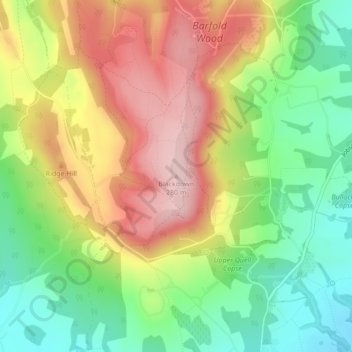
Name: Blackdown topographic map, elevation, terrain.
Average elevation: 541 ft
Minimum elevation: 207 ft
Maximum elevation: 919 ft
Make a donation
Gear up for your next adventure:
As an Amazon Associate, this site earns from qualifying purchases at no extra cost to you.
Other topographic maps
Click on a map to view its topography, its elevation and its terrain.
Make a donation
Gear up for your next adventure:
As an Amazon Associate, this site earns from qualifying purchases at no extra cost to you.
Selsey
United Kingdom > England > West Sussex > Chichester
A study published by Princeton University and McGill University, in 2020, concluded that the Manhood Peninsula is at particularly high risk of flooding as its topography is less than 5 metres (16 ft) above the current mean sea level and that by 2100 Selsey will be subject to permanent inundation.
Average elevation: 3 ft
West Wittering
United Kingdom > England > West Sussex > Chichester > West Wittering
Average elevation: 7 ft
Make a donation
Gear up for your next adventure:
As an Amazon Associate, this site earns from qualifying purchases at no extra cost to you.
Make a donation
Gear up for your next adventure:
As an Amazon Associate, this site earns from qualifying purchases at no extra cost to you.
Harting
United Kingdom > England > West Sussex > Chichester > South Harting
Because of its elevation Beacon Hill, just to the east of Harting Down, hosted a station in the shutter telegraph chain, from 1796 to 1816, which connected the Admiralty in London to its naval ships in Portsmouth and Plymouth. This was replaced in 1822 by a semaphore station which operated on a slightly…
Average elevation: 331 ft
Make a donation
Gear up for your next adventure:
As an Amazon Associate, this site earns from qualifying purchases at no extra cost to you.
Make a donation
Gear up for your next adventure:
As an Amazon Associate, this site earns from qualifying purchases at no extra cost to you.
Make a donation
Gear up for your next adventure:
As an Amazon Associate, this site earns from qualifying purchases at no extra cost to you.
Donnington Park
United Kingdom > England > West Sussex > Chichester > Apuldram
Average elevation: 26 ft
Make a donation
Gear up for your next adventure:
As an Amazon Associate, this site earns from qualifying purchases at no extra cost to you.
Make a donation
Gear up for your next adventure:
As an Amazon Associate, this site earns from qualifying purchases at no extra cost to you.
Upwaltham
United Kingdom > England > West Sussex > Chichester
The Skytrain was from the 27th Transport Group. On 11 February 1945 it was on a flight from Paris–Le Bourget Airport to RAF Grove in Berkshire. It crossed the Sussex coast about 1125 hrs at an altitude of only 300 to 400 feet (91 to 122 m). The weather was worsening, visibility had decreased to 25 yards (23…
Average elevation: 499 ft
Make a donation
Gear up for your next adventure:
As an Amazon Associate, this site earns from qualifying purchases at no extra cost to you.
Make a donation
Gear up for your next adventure:
As an Amazon Associate, this site earns from qualifying purchases at no extra cost to you.
Barlavington
United Kingdom > England > West Sussex > Chichester > Barlavington
Average elevation: 164 ft
Horncroft Common Plantation
United Kingdom > England > West Sussex > Chichester
Average elevation: 72 ft
Make a donation
Gear up for your next adventure:
As an Amazon Associate, this site earns from qualifying purchases at no extra cost to you.
Selsey
United Kingdom > England > West Sussex > Chichester
A study published by Princeton University and McGill University, in 2020, concluded that the Manhood Peninsula is at particularly high risk of flooding as its topography is less than 5 metres (16 ft) above the current mean sea level and that by 2100 Selsey will be subject to permanent inundation.
Average elevation: 3 ft
Make a donation
Gear up for your next adventure:
As an Amazon Associate, this site earns from qualifying purchases at no extra cost to you.
Upwaltham
United Kingdom > England > West Sussex > Chichester
The Skytrain was from the 27th Transport Group. On 11 February 1945 it was on a flight from Paris–Le Bourget Airport to RAF Grove in Berkshire. It crossed the Sussex coast about 1125 hrs at an altitude of only 300 to 400 feet (91 to 122 m). The weather was worsening, visibility had decreased to 25 yards (23…
Average elevation: 499 ft
Make a donation
Gear up for your next adventure:
As an Amazon Associate, this site earns from qualifying purchases at no extra cost to you.
Selsey
United Kingdom > England > West Sussex > Chichester
A study published by Princeton University and McGill University, in 2020, concluded that the Manhood Peninsula is at particularly high risk of flooding as its topography is less than 5 metres (16 ft) above the current mean sea level and that by 2100 Selsey will be subject to permanent inundation.
Average elevation: 3 ft
Make a donation
Gear up for your next adventure:
As an Amazon Associate, this site earns from qualifying purchases at no extra cost to you.