Geolocate

Lares topographic map

Click on the map to display elevation.

About this map

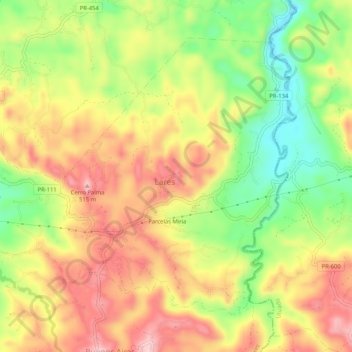
Name: Lares topographic map, elevation, terrain.

Location: Lares, Puerto Rico, 00669, United States (18.27573 -66.87546 18.31460 -66.82349)

Average elevation: 1,270 ft

Minimum elevation: 883 ft

Maximum elevation: 1,617 ft

Puerto Rico trails, hiking, mountain biking, running and outdoor activities

Other topographic maps

Click on a map to view its topography, its elevation and its terrain.

Cerro Santo Domingo

United States > Puerto Rico > Lares

Average elevation: 1,880 ft

Gear up for your next adventure:

🥘Titanium Cookware - Durable, featherlight pots and pans for backpacking
📱Solar Portable Charger - Solar power bank for charging devices off‑grid
🗻Climbing Gear Basics - Essential gear for beginner climbers
🪶Survival Guide Book - Expert advice for emergency preparedness
🔭Telescopic Hiking Pole - Adjustable pole for hiking stability

As an Amazon Associate, this site earns from qualifying purchases at no extra cost to you.