
Tarumã topographic map
Click on the map to display elevation.
About this map
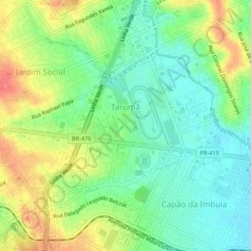
Name: Tarumã topographic map, elevation, terrain.
Average elevation: 2,969 ft
Minimum elevation: 2,887 ft
Maximum elevation: 3,084 ft
Other topographic maps
Click on a map to view its topography, its elevation and its terrain.
Praça Santos Andrade
Brasil > Paraná > Região Metropolitana de Curitiba > Curitiba
Average elevation: 2,986 ft
Parque Náutico
Brasil > Paraná > Região Metropolitana de Curitiba > Curitiba
Average elevation: 2,874 ft
Rio Água Verde
Brasil > Paraná > Região Metropolitana de Curitiba > Curitiba > Vila Torres
Average elevation: 2,956 ft
Bosque Reinhard Maack
Brasil > Paraná > Região Metropolitana de Curitiba > Curitiba
Average elevation: 2,966 ft
Rio Passaúna
Brasil > Paraná > Região Metropolitana de Curitiba > Curitiba
Average elevation: 3,025 ft
Jardim Botânico de Curitiba
Brasil > Paraná > Região Metropolitana de Curitiba > Curitiba
Average elevation: 2,989 ft
Parque Municipal do Passaúna
Brasil > Paraná > Região Metropolitana de Curitiba > Curitiba
Average elevation: 3,009 ft
Parque Tingui
Brasil > Paraná > Região Metropolitana de Curitiba > Curitiba
Average elevation: 3,091 ft
Bosque de Portugal
Brasil > Paraná > Região Metropolitana de Curitiba > Curitiba
Average elevation: 2,992 ft
Praça das Nações
Brasil > Paraná > Região Metropolitana de Curitiba > Curitiba
Average elevation: 2,989 ft
Praça Zumbi dos Palmares
Brasil > Paraná > Região Metropolitana de Curitiba > Curitiba
Average elevation: 3,018 ft
Praça Bento Munhoz da Rocha Neto
Brasil > Paraná > Região Metropolitana de Curitiba > Curitiba
Average elevation: 2,995 ft
Jardinete Osmar Carta
Brasil > Paraná > Região Metropolitana de Curitiba > Curitiba
Average elevation: 3,051 ft