

Chetwynd topographic map
Click on the map to display elevation.
Chetwynd
Carved out of an ancient floodplain, the small terrace upon which Chetwynd is situated lies in the northern foothills of the Rocky Mountains. Once used as a grazing spot by nomadic Aboriginals, the terrace was farmed by settlers until it was developed into a town. Two types of soil—namely, the Widmark and Centurion Series—comprise the terrace's surface. The Widmark Series—a moderately well-drained degraded loamy, woody, silty, and clay-like soil—lies north of Highway 97. Meanwhile, the Centurion Series—which lies south of the highway—is a poorly drained soil with a dark-brown peaty surface material consisting of decomposed leaves and mosses. These soils, also limited by topography and stoniness, are generally used for forage and pasture.
About this map
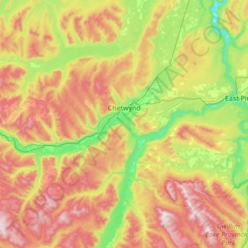
Name: Chetwynd topographic map, elevation, terrain.
Average elevation: 2,986 ft
Minimum elevation: 1,539 ft
Maximum elevation: 5,446 ft
Other topographic maps
Click on a map to view its topography, its elevation and its terrain.
Dawson Creek
Canada > British Columbia > Peace River Regional District > Dawson Creek
Average elevation: 2,425 ft
Tsay Keh Dene Nation
Canada > British Columbia > Peace River Regional District > Area B (Finlay Valley/Beatton Valley)
Average elevation: 2,257 ft
Van Somer Point
Canada > British Columbia > Peace River Regional District > Area B (Finlay Valley/Beatton Valley)
Average elevation: 2,198 ft
Black Bear Ridge
Canada > British Columbia > Peace River Regional District > Area B (Finlay Valley/Beatton Valley)
Average elevation: 4,311 ft
Mount Hermann
Canada > British Columbia > Peace River Regional District > Tumbler Ridge
Average elevation: 4,721 ft
Carbon Peak
Canada > British Columbia > Peace River Regional District > Area E (Moberly Lake/Sukunka Valley)
Average elevation: 4,662 ft