Geolocate

Zlatar topographic map

Click on the map to display elevation.

About this map

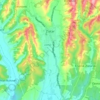
Name: Zlatar topographic map, elevation, terrain.

Location: Zlatar, Grad Zlatar, Krapina-Zagorje County, 49250, Croatia (46.06007 16.05872 46.10756 16.10221)

Average elevation: 663 ft

Minimum elevation: 495 ft

Maximum elevation: 991 ft

Other topographic maps

Click on a map to view its topography, its elevation and its terrain.

Krapina

Croatia > Krapina-Zagorje County

Average elevation: 938 ft

Šagudovec

Croatia > Krapina-Zagorje County > Šagudovec

Average elevation: 860 ft

Mihovljan

Croatia > Krapina-Zagorje County

Average elevation: 755 ft

Gear up for your next adventure:

🎒Trekking Poles - Sturdy poles for balance and stability on rough terrain
📷Action Cameras - Rugged cameras to document your journeys across rugged terrain
🖼️Topo Map Wall Art - Decorative topographic prints of famous peaks and regions
🔭Stargazing Telescopes - Perfect for camping in low-light pollution areas shown on maps
🪶Survival Guide Book - Expert advice for emergency preparedness

As an Amazon Associate, this site earns from qualifying purchases at no extra cost to you.