Geolocate

Krapina topographic map

Click on the map to display elevation.

About this map

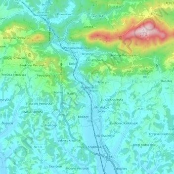
Name: Krapina topographic map, elevation, terrain.

Location: Krapina, Grad Krapina, Krapina-Zagorje County, 49000, Croatia (46.12280 15.83111 46.20280 15.91111)

Average elevation: 938 ft

Minimum elevation: 525 ft

Maximum elevation: 2,726 ft

Other topographic maps

Click on a map to view its topography, its elevation and its terrain.

Zlatar

Croatia > Krapina-Zagorje County

Average elevation: 663 ft

Gear up for your next adventure:

🛏️Cold Weather Sleeping Bag - Warm sleeping bag for cold conditions
🦟Ultrasonic Repellers - Create a bug-free zone at your camp or rest stop
🛰️Satellite Messengers - Emergency SOS and two-way messaging for off-grid adventures
🧢Sun Protection Hats - Wide-brimmed and UPF-rated hats for high-altitude sun safety
🧭Pro Hiking Compasses - High-accuracy liquid-filled compasses for topographic orientation

As an Amazon Associate, this site earns from qualifying purchases at no extra cost to you.