
Make a donation
Gear up for your next adventure:
As an Amazon Associate, this site earns from qualifying purchases at no extra cost to you.
Bonnert topographic map
Click on the map to display elevation.
Make a donation
Gear up for your next adventure:
As an Amazon Associate, this site earns from qualifying purchases at no extra cost to you.
About this map
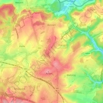
Name: Bonnert topographic map, elevation, terrain.
Location: Bonnert, Arlon, Luxembourg, Wallonie, Belgique (49.67056 5.77793 49.72096 5.86750)
Average elevation: 1,224 ft
Minimum elevation: 961 ft
Maximum elevation: 1,437 ft
Make a donation
Gear up for your next adventure:
As an Amazon Associate, this site earns from qualifying purchases at no extra cost to you.
Other topographic maps
Click on a map to view its topography, its elevation and its terrain.
Make a donation
Gear up for your next adventure:
As an Amazon Associate, this site earns from qualifying purchases at no extra cost to you.
Autelbas-Barnich
Belgique > Luxembourg > Arlon > Arlon
L’altitude à Autelbas-Barnich est d’environ 330 m.
Average elevation: 1,102 ft