
Make a donation
Gear up for your next adventure:
As an Amazon Associate, this site earns from qualifying purchases at no extra cost to you.
Sterpenich topographic map
Click on the map to display elevation.
Make a donation
Gear up for your next adventure:
As an Amazon Associate, this site earns from qualifying purchases at no extra cost to you.
About this map
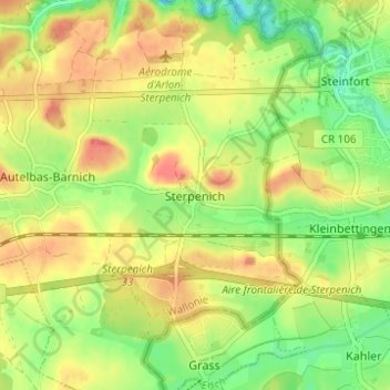
Name: Sterpenich topographic map, elevation, terrain.
Location: Sterpenich, Arlon, Luxembourg, Wallonie, 6706, Belgique (49.62797 5.87090 49.66797 5.91090)
Average elevation: 1,073 ft
Minimum elevation: 961 ft
Maximum elevation: 1,181 ft
Make a donation
Gear up for your next adventure:
As an Amazon Associate, this site earns from qualifying purchases at no extra cost to you.
Other topographic maps
Click on a map to view its topography, its elevation and its terrain.
Guirsch
Belgique > Luxembourg > Arlon > Arlon
Le village de Guirsch est par conséquent localisé sur un site plateau entouré de profondes vallées entaillant la cuesta. Le sommet du village s'établit à une altitude de 402,30 mètres à l'ouest (chapelle Saint-Willibrord) à 394,18 mètres au centre (église Saint-Willibrord), alors que le moulin de la…
Average elevation: 1,168 ft
Autelbas
Belgique > Luxembourg > Arlon > Arlon
L’altitude à Autelbas-Barnich est d’environ 330 m.
Average elevation: 1,109 ft
Make a donation
Gear up for your next adventure:
As an Amazon Associate, this site earns from qualifying purchases at no extra cost to you.