
Make a donation
Gear up for your next adventure:
As an Amazon Associate, this site earns from qualifying purchases at no extra cost to you.
Danbury topographic map
Click on the map to display elevation.
Make a donation
Gear up for your next adventure:
As an Amazon Associate, this site earns from qualifying purchases at no extra cost to you.
Danbury
The highest point in Danbury is the summit of Tinkham Hill, at 2,320 feet (710 m) above sea level, in the northern part of town. Ragged Mountain is a prominent mountain with multiple summits which occupies the southern portion of town and has a ski area of the same name; the elevation of the Danbury summit of Ragged is 2,225 ft (678 m) above sea level. The Sunapee-Ragged-Kearsarge Greenway hiking trail crosses a corner of Danbury along Ragged Mountain's Ridge Trail. Access to the Ridge Trail from the SRK Greenway is on the SRKG 6.1 mile trail section 9, either from trailhead parking on New Canada Road in Wilmot from the northwest or from Proctor Academy's trailhead parking in Andover from the southeast.
Make a donation
Gear up for your next adventure:
As an Amazon Associate, this site earns from qualifying purchases at no extra cost to you.
About this map
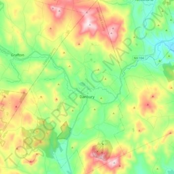
Name: Danbury topographic map, elevation, terrain.
Average elevation: 1,145 ft
Minimum elevation: 453 ft
Maximum elevation: 2,297 ft
Make a donation
Gear up for your next adventure:
As an Amazon Associate, this site earns from qualifying purchases at no extra cost to you.
Other topographic maps
Click on a map to view its topography, its elevation and its terrain.
Catamount Mountain
United States > New Hampshire > Merrimack County > Pittsfield
Average elevation: 922 ft
Make a donation
Gear up for your next adventure:
As an Amazon Associate, this site earns from qualifying purchases at no extra cost to you.
Kezer Seminary
United States > New Hampshire > Merrimack County > Canterbury
Average elevation: 633 ft
Make a donation
Gear up for your next adventure:
As an Amazon Associate, this site earns from qualifying purchases at no extra cost to you.
Shaker Village
United States > New Hampshire > Merrimack County > Canterbury
Average elevation: 673 ft
Make a donation
Gear up for your next adventure:
As an Amazon Associate, this site earns from qualifying purchases at no extra cost to you.
Make a donation
Gear up for your next adventure:
As an Amazon Associate, this site earns from qualifying purchases at no extra cost to you.
Rings Corner
United States > New Hampshire > Merrimack County > Pittsfield > Rings Corner
Average elevation: 623 ft